Contributed by Maine Historical Society/MaineToday Media

- MMN #36141
- print page
- download web image
Purchase a reproduction of this item on VintageMaineImages.com.
Description
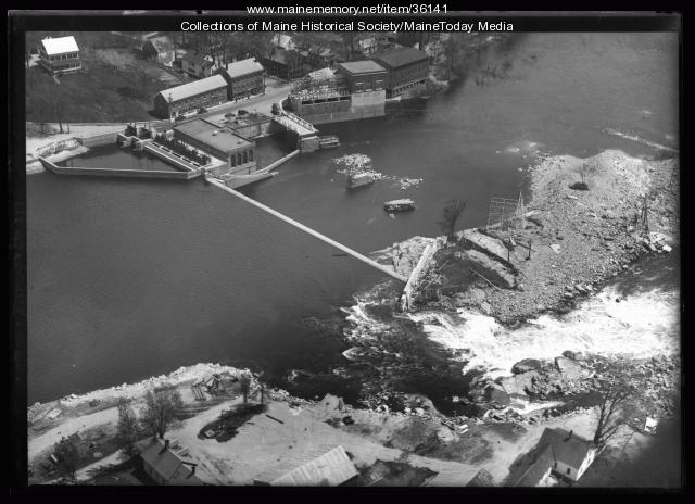
Aerial view of the Saco River during a flood that washed the West Buxton bridge away. The West Buxton dam can be seen, as well as the flooded area. Rt. 112 runs along the river near the power generating station.
On the far left is the landing for the ferry from Boom Rd. on the Buxton side to the Hollis side which used while the bridge was out.
The buildings from left to right on the far side of the river include the parsonage for the West Buxton Free Will Baptist Church, York Mutual Insurance Company, Win Townsend's store and the Masonic Lodge, Christian Row Rd., Stan Townsend's building and the barber shop, the Tydol Gasoline station, bank, surge station and the woolen mill.
About This Item
- Title: West Buxton and a flooded Saco River, ca. 1936
- Creation Date: circa 1936
- Subject Date: circa 1936
- Location: West Buxton, York County, ME
- Media: Glass Negative
- Dimensions: 12.7 cm x 17.8 cm
- Local Code: Coll. 1949, 2005.061.A202
- Collection: Portland Press Herald glass negative collection
- Object Type: Image
Cross Reference Searches
Standardized Subject Headings
- Buildings--Maine--West Buxton
- Dams--Maine--West Buxton
- Floods--Maine--West Buxton
- Rivers--Maine
- Saco River (N.H. and Me.)
- West Buxton (Me.)--Flood, 1936
For more information about this item, contact:
Maine Historical Society/MaineToday Media489 Congress Street, Portland, ME 04101
(207) 774-1822 x230
Website
This Item is protected by copyright and/or related rights. No Permission is required to use the low-resolution watermarked image for educational use, or as allowed by the applicable copyright. For all other uses, permission is required.
Please post your comment below to share with others. If you'd like to privately share a comment or correction with MMN staff, please send us a message with this link.

