Keywords: 20 Mile River
Item 4318

Androscoggin River above Lewiston, ca. 1750
Contributed by: Maine Historical Society Date: circa 1750 Location: Turner; Livermore; Wayne; Leeds Media: Ink on paper
Item 122824

Plymouth Company Records, box 2/20, ca. 1766
Contributed by: Maine Historical Society
Date: circa 1766
Location: Dresden
Media: Ink on Paper
This record contains 30 images.

Exhibit

Colonial Cartography: The Plymouth Company Maps
The Plymouth Company (1749-1816) managed one of the very early land grants in Maine along the Kennebec River. The maps from the Plymouth Company's collection of records constitute some of the earliest cartographic works of colonial America.
Exhibit

Wired! How Electricity Came to Maine
As early as 1633, entrepreneurs along the Piscataqua River in southern Maine utilized the force of the river to power a sawmill, recognizing the potential of the area's natural power sources, but it was not until the 1890s that technology made widespread electricity a reality -- and even then, consumers had to be urged to use it.

Site Page

Life on a Tidal River - Narrative
"… its college would be founded in 1865 just eight miles up river from Bangor. Initially known as the Maine State College, Maine's public institution…"
Site Page
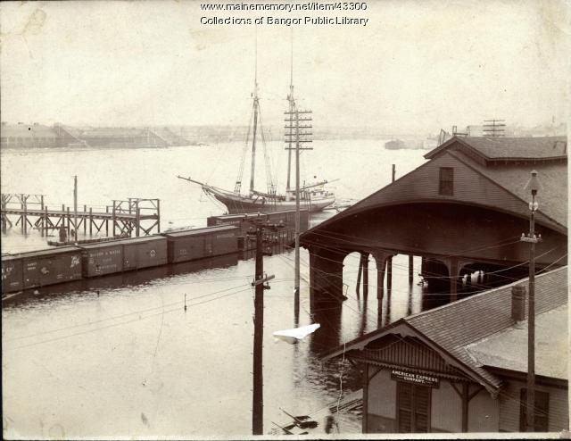
Life on a Tidal River - The Great Bangor Floods: 1902 and 1976
"… Penobscot River during the Bangor flood of March 20, 1902.Bangor Public Library Text by The 7th Grade Maine Studies Students of the William S."

Story

Wabanaki-Greenland connections
by Jennifer Sapiel Neptune
Exploring cultural resiliency in this time of rapidly changing climate.
Story

John Coyne from Waterville Enlists as a Railroad Man in WWI
by Mary D. Coyne
Description of conditions railroad men endured and family background on John Coyne.
