Keywords: Fort Fairfield Road
Item 22215
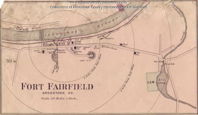
Map of Fort Fairfield, ca. 1870
Contributed by: Aroostook County Historical and Art Museum Date: circa 1870 Location: Fort Fairfield Media: Ink on paper
Item 6489

Main Street, Fort Fairfield, 1890
Contributed by: University of Maine at Presque Isle Library Date: circa 1890 Location: Fort Fairfield Media: Photographic print

Exhibit

Maine Streets: The Postcard View
Photographers from the Eastern Illustrating and Publishing Co. of Belfast traveled throughout the state, especially in small communities, taking images for postcards. Many of these images, taken in the first three decades of the twentieth century, capture Main Streets on the brink of modernity.
Exhibit

Construction of the Bangor and Aroostook rail lines into northern Aroostook County in the early twentieth century opened the region to tourism and commerce from the south.
Site Page

Maine's Swedish Colony, July 23, 1870 - Maine Railroads
"In 1892 the route from Houlton to Van Buren, Fort Fairfield, and Ashland was completed. As a result of building the Aroostook railroad, the Aroostook…"
Site Page

Presque Isle: The Star City - History of Presque Isle
"… thriving towns of Presque Isle, Caribou and Fort Fairfield, with an average population of about 4000 each and an average valuation crowding well up…"