Keywords: Red Line Map
Item 105920

Redline map of Portland and South Portland, 1935
Contributed by: Maine Historical Society Date: 1935-11-15 Location: Portland; South Portland Media: Ink on paper
Item 110888

Map of the Northern part of the state of Maine and of the adjacent British Provinces, 1830
Contributed by: Maine Historical Society
Date: circa 1830
Media: Ink on paper
This record contains 2 images.

Exhibit
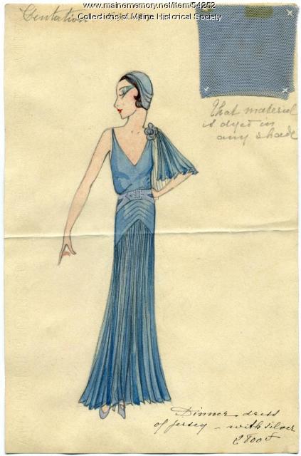
Cosmopolitan stylings of Mildred and Madeleine Burrage
Born in Portland, sisters Mildred Giddings Burrage (1890-1983) and Madeleine Burrage (1891-1976) were renowned artists and world travelers. Mildred's experiences studying painting in Paris and Italy, and the sisters' trips to Mexico and Guatemala inspired their artwork and shared passions for cosmopolitan and stylish attire. Housed at Maine Historical Society, The Burrage Papers include selections of original advertising drawings called "line sheets" from Parisian fashion houses dating from 1928 to 1936. Images of Madeleine's gemstone jewelry and Mildred's artwork accompany intimate family photographs of the sisters.
Exhibit

The history of the region now known as Maine did not begin at statehood in 1820. What was Maine before it was a state? How did Maine separate from Massachusetts? How has the Maine we experience today been shaped by thousands of years of history?

Site Page

"3 (July 1997), 515-548 Dunbabin, J. P. D. “Red Lines on Maps: The Impact of Cartographical Errors on the Border between the United States and British…"
Site Page
"Champlain’s early map gives this island the name “Brule-Cote,” meaning “Burnt-hill” in his native French, presumably due to evidence of past fires on…"

Story
John Coyne from Waterville Enlists as a Railroad Man in WWI
by Mary D. Coyne
Description of conditions railroad men endured and family background on John Coyne.
Story

Vietnam Memoirs
by David Chessey
MY PERSONAL EXPERIENCES AND MY OBSERVATION OF NATIONWIDE OPINIONS CONCERNING THE “VIET NAM" WAR
