Keywords: Survey Map
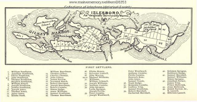
Item 28353
Warren Survey Map, Islesboro, ca. 1893
Contributed by: Islesboro Historical Society Date: circa 1799 Location: Islesboro Media: Ink on paper
Item 78950
Salem Towne Map, Mount Desert Island, ca. 1808
Contributed by: Mount Desert Island Historical Society Date: circa 1808 Location: Mount Desert Island Media: Map
Item 151873
Danielson residence, Northeast Harbor, 2013
Contributed by: Maine Historical Society Date: 2013 Location: Mount Desert Client: Barbara S. Danielson Architect: Sage Collins Surveying, Inc.
Item 151800
Mori residence, North Haven, 2016-2018
Contributed by: Maine Historical Society Date: 2016–2018 Location: North Haven Client: Toshiko Mori Architect: LaBranche Land Surveys
Exhibit
Colonial Cartography: The Plymouth Company Maps
The Plymouth Company (1749-1816) managed one of the very early land grants in Maine along the Kennebec River. The maps from the Plymouth Company's collection of records constitute some of the earliest cartographic works of colonial America.
Exhibit
The boundaries of Maine are the product of international conflict, economic competition, political fights, and contested development. The boundaries are expressions of human values; people determined the shape of Maine.
Site Page
Beyond Borders - Mapping Maine and the Northeast Boundary - People
"Map by Francis Joseph Neptune, Cobscook River, 1798 Map by cartographer Chief Francis Joseph Neptune (Passamaquoddy), 1798Maine Historical Society…"
Site Page
Beyond Borders - Mapping Maine and the Northeast Boundary - Borderland Essays
"… today the American state of Maine and the Canadian province of New Brunswick. Map of Campobello Island, ca. 1840Maine Historical Society"


