Keywords: lot map
Item 96522

Baldwin and Sebago lot map, ca. 1820
Contributed by: Baldwin Historical Society Date: circa 1805 Location: Baldwin; Sebago Media: ink on paper
Item 108835

Plan of lots 1-10, Fairfield, 1782
Contributed by: Maine Historical Society
Date: 1782-12-20
Location: Fairfield
Media: Ink on paper
This record contains 2 images.

Item 151846

Cushman residence, Seal Harbor, 1993-1999
Contributed by: Maine Historical Society Date: 1993–1999 Location: Mount Desert Clients: Roderick Cushman; Verena Cushman Architect: Patrick Chasse; Landscape Design Associates
Item 151221

The Mount, Lenox, Massachusetts, 1980-1999
Contributed by: Maine Historical Society Date: 1980–1999 Location: Lenox Client: The Mount, Edith Wharton's Home Architect: Patrick Chasse; Landscape Design Associates

Exhibit

Colonial Cartography: The Plymouth Company Maps
The Plymouth Company (1749-1816) managed one of the very early land grants in Maine along the Kennebec River. The maps from the Plymouth Company's collection of records constitute some of the earliest cartographic works of colonial America.
Exhibit

The boundaries of Maine are the product of international conflict, economic competition, political fights, and contested development. The boundaries are expressions of human values; people determined the shape of Maine.

Site Page

Beyond Borders - Mapping Maine and the Northeast Boundary - Pejepscot Proprietors Papers, 1627‐1866
"Pejepscot Proprietors Papers, 1627‐1866 Map of lots on Maquoit & Merriconeeg, ca. 1719Maine Historical Society Coll."
Site Page

"… pointing out that the proprietors hoarded choice lots for their own use, hindering community prosperity."

Story
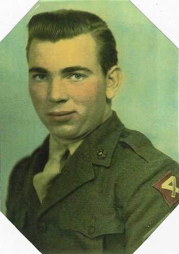
My father, Earle Ahlquist, served during World War II
by Earlene Chadbourne
Earle Ahlquist used his Maine common sense during his Marine service and to survive Iwo Jima
Story

Vietnam Memoirs
by David Chessey
MY PERSONAL EXPERIENCES AND MY OBSERVATION OF NATIONWIDE OPINIONS CONCERNING THE “VIET NAM" WAR
