Keywords: Road maps
- Historical Items (154)
- Tax Records (0)
- Architecture & Landscape (51)
- Online Exhibits (23)
- Site Pages (63)
- My Maine Stories (4)
- Lesson Plans (0)
Site Pages
These sites were created for each contributing partner or as part of collaborative community projects through Maine Memory. Learn about collaborative projects on MMN.
Site Page

Maine's Road to Statehood - Overview: Road to Statehood
"Overview: Road to Statehood Map of the Inhabited Part of Maine, Moses Greenleaf, 1829Maine Historical Society Many know that the Missouri…"
Site Page

Maine's Road to Statehood - The Coasting Law of 1789
"… coincide with Maine's separation.[10] New Map of English America, 1677 Since Massachusetts was adjacent to New Hampshire, Connecticut, New…"
Site Page

Maine's Road to Statehood - Maine in the 17th Century
"Maine in the 17th Century Map of New England and New York, ca. 1676 Largely an unexplored territory by European settlers, 17th century Maine…"
Site Page

Maine's Road to Statehood - The Missouri Compromise: A Moral Dilemma
"Map of the State of Maine, 1820Osher Map Library and Smith Center for Cartographic Education Within the United States, a greater sectional debate…"
Site Page

Maine's Road to Statehood - 1790s: A Growing Movement
"… effort soon died out.[16] District of Maine map, 1795 Drawn in 1795, this map promoted the separation of Maine from Massachusetts."
Site Page

Scarborough: They Called It Owascoag - Scarborough Marsh: "Land of Much Grass" - Page 2 of 4
"Moses Banks’ 1784 survey map became the basis for all marsh lot purchases, work and disputes involving these companies."
Site Page

Scarborough: They Called It Owascoag - Historical Overview - Page 1 of 4
"Historical Overview Map of Scarborough with MarshlandScarborough Historical Society & Museum Scarborough: They Called it Owascoag Text by…"
Site Page

Maine's Road to Statehood - The Final Vote
"The Final Vote William Williamson to Joseph Williamson on the final vote for separation, Boston, 1819Maine Historical Society For several…"
Site Page

"He was responsible for the upkeep of the Wells-Brunswick road and helped transport soldiers to the Brunswick fort."
Site Page

Maine's Road to Statehood - The American Revolution and Early Attempts at Separation - Page 2 of 2
"The American Revolution and Early Attempts at Separation The committee sent a similar address to the citizens of Maine urging them to support…"
Site Page

Maine's Road to Statehood - The American Revolution and Early Attempts at Separation - Page 1 of 2
"The American Revolution and Early Attempts at Separation Overwhelmingly dedicated to independence from Britain, Mainers quieted any murmurs of…"
Site Page

Maine's Road to Statehood - After the War: The First Victory for Separationists
"After the War: The First Victory for Separationists The "Boxer" and "Enterprise," Monhegan, 1831 This painting depicts an 1813 battle between…"
Site Page
Maine's Road to Statehood - Turn of the Century to the War of 1812
"Turn of the Century to the War of 1812 The 1800s welcomed a plethora of economic and demographic changes for the District of Maine."
Site Page
"… occasions, physically assaulting them on the road or even in their homes. Clashes between the Great Proprietors and frontier residents climaxed in…"
Site Page

"… to substantiate company land claims, and the roads, mills, and meetinghouses they built helped make the rest of the proprietors’ tracts more…"
Site Page

"… Moose River, Moose Head Lake and Kennebeck Road, 1820Maine Historical Society Historian Francis M. Carroll’s A Good and Wise Measure: The Search…"
Site Page

Bath's Historic Downtown - Intersection of Centre and Washington
"According to several city maps, around 1910, the church had a vestry added to it. In 1890, a large organ was purchased for the church."
Site Page

Bath's Historic Downtown - History Overview
"This new road, later called State Road, entered Bath on building Washington Streets. The resulting congestion led to installation of Bath’s first…"
Site Page

Farmington: Franklin County's Shiretown - The Brick Inn
"… has been noted on this 1861 Walling Topographical Map of the Franklin County with Town of Farmington noted (map from Library of Congress)."
Site Page

Farmington: Franklin County's Shiretown - Early Settlers
"Early Settlers Click the icon for a map of the locations of early settler's homesteads X By Nancy Porter, Researcher & Page Creator With…"
Site Page

Farmington: Franklin County's Shiretown - Brief History
"… Library, and Maine Historical Society 1794 map of FarmingtonFarmington Historical Society "Farmington is undoubtly one of the best…"
Site Page

Farmington: Franklin County's Shiretown - Agriculture
"Regional History Reprints. Originally published in 1846. Franklin Chronicle Newspapers. 1840-1918. Various magazine articles and maps."
Site Page
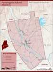
Farmington: Franklin County's Shiretown - Education
"Education Click the icon to see a map of the early schools of Farmington. X By Nancy Porter, Researcher and Page Creator With images from…"
Site Page

Bath's Historic Downtown - Project Resources
"… 1894, “History of Bath and Environs, 1607-1894.” Maps Map of Part of the Town of Bath, A. Hammett, circa 1830. City of Bath, Lincoln County, Maine."
