Category: Nature & Geography
- Historical Items (4973)
- Tax Records (0)
- Architecture & Landscape (0)
- Online Exhibits (43)
- Site Pages (678)
- My Maine Stories (55)
- Lesson Plans (8)
Historical Items
These results include photographs, documents, letters, paintings, artifacts, and many other kinds of Maine related items from collections around the state and elsewhere.
Item 111004

Mouth of Detroit River, ca. 1820
Contributed by: Maine Historical Society
Date: circa 1820
Media: Ink on paper
This record contains 4 images.
Item 111022

A plane chart of Rainy Lake, ca. 1820
Contributed by: Maine Historical Society
Date: circa 1820
Media: Ink on paper
This record contains 5 images.
Item 116500

Sketch of Drummond Island and straight between Lake Huron and Superior, ca. 1820
Contributed by: Maine Historical Society
Date: circa 1820
Location: Sault Sainte Marie; Sault Ste. Marie
Media: Ink on paper
This record contains 2 images.
Item 116522

Drummond's Island, Lesser and Greater Manitou, ca. 1820
Contributed by: Maine Historical Society Date: circa 1820 Media: Ink on paper
Item 135798

"An Appeal to the Friends of Science," Portland, 1866
Contributed by: Maine Historical Society Date: 1866 Location: Portland Media: Ink on paper
Item 149686

Contributed by: Acadian Archives Date: circa 1835 Media: Ink on paper
Item 149687

Contributed by: Acadian Archives Date: circa 1831 Media: Ink on paper
Item 149688

Contributed by: Acadian Archives Date: 1838 Media: Ink on paper
Item 9600

Cocumgomucsis Lake view to Katahdin, Talcott Survey, 1841
Contributed by: Maine Historical Society Date: 1840 Media: Phototransparency
Item 20766

Manuscript Map of Moose River, Moosehead Lake, and Kennebeck Road, 1820
Contributed by: Maine Historical Society Date: 1820 Media: Ink on paper
Item 66609

Map of Mt. Desert Island printed on postcard, ca. 1935
Contributed by: Boston Public Library Date: circa 1935 Location: Mount Desert Island Media: Linen texture postcard
Item 4318

Androscoggin River above Lewiston, ca. 1750
Contributed by: Maine Historical Society Date: circa 1750 Location: Turner; Livermore; Wayne; Leeds Media: Ink on paper
Item 4317

Cathance Mill lots, Topsham, 1759
Contributed by: Maine Historical Society
Date: 1759-01-05
Location: Topsham
Media: Ink on paper
This record contains 2 images.
Item 4319

Contributed by: Maine Historical Society Date: circa 1795 Location: Freeport; New Gloucester; Brunswick Media: Ink on paper
Item 4323
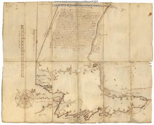
Contributed by: Maine Historical Society
Date: 1738
Location: Brunswick; Harpswell; Topsham
Media: Ink on paper
This record contains 2 images.
Item 4325

"Brunswick in the late Province of Mayne in New England," 1719
Contributed by: Maine Historical Society
Date: 1718-01-28
Location: Brunswick
Media: Ink on paper
This record contains 2 images.
Item 5314

Plan of rivers of Saco and Kennebunk, 1731
Contributed by: Maine Historical Society Date: 1731 Media: Ink on paper
Item 5547

Aerial view looking toward Lubec, ca. 1950
Contributed by: Maine Historical Society Date: circa 1950 Location: Lubec Media: Photographic print
Item 6063

Park Street after the ice storm, Portland, 1886
Contributed by: Maine Historical Society Date: 1886 Location: Portland Media: Albumen print
Item 6297

Getting seaweed, Sheepscot Bay, ca. 1890
Contributed by: Maine Historical Society Date: circa 1890 Media: Etching
Item 6317

Thomas Steele "discovers" lake near Matagamon Lake, 1879
Contributed by: Maine Historical Society Date: 1879 Location: Mattamiscontis Twp. Media: Ink on paper
Item 6513

Orr's Island in winter, ca. 1930
Contributed by: Maine Historical Society Date: circa 1930 Location: Harpswell Media: Photographic print
Item 6885

Plan of James Deering's Farm, Portland, 1843
Contributed by: Maine Historical Society Date: 1843 Location: Portland Media: Ink on paper
Item 7541

Reproduction of 1620 Charter from King James I to the Council for New England, 1885
Contributed by: Maine Historical Society Date: 1620-11-03 Media: Ink on paper
