Category: Nature & Geography
- Historical Items (4973)
- Tax Records (0)
- Architecture & Landscape (0)
- Online Exhibits (43)
- Site Pages (678)
- My Maine Stories (55)
- Lesson Plans (8)
Historical Items
These results include photographs, documents, letters, paintings, artifacts, and many other kinds of Maine related items from collections around the state and elsewhere.
Item 7950

Islands in Passamaquoddy Bay, ca. 1800
Contributed by: Maine Historical Society
Date: circa 1800
Media: Ink on paper
This record contains 2 images.
Item 8410

C. Murphy & Son's Landing, Maine, ca. 1900
Contributed by: Patten Lumbermen's Museum Date: circa 1900 Media: Photographic print
Item 8714

Lake in winter, Waterford, ca. 1905
Contributed by: Waterford Historical Society Date: circa 1905 Location: Waterford Media: Photographic print
Item 9259

Early map of the Salmon Falls River in Lebanon, 1766
Contributed by: Maine Historical Society Date: 1766 Location: Lebanon Media: Ink on paper
Item 9597

View from Station 212, Talcott survey, 1841
Contributed by: Maine Historical Society Date: 1841 Media: Phototransparency
Item 9602

Katahdin, as seen from Chamberlain Lake, 1839
Contributed by: Maine Historical Society Date: 1841 Media: Transparency
Item 10537

Contributed by: Maine Historical Society Date: 1717 Location: Brunswick Media: Ink on paper
Item 10762

Enclosure map, Stroudwater, 1756
Contributed by: Maine Historical Society Date: 1756 Location: Portland; Westbrook Media: Ink on paper
Item 11714
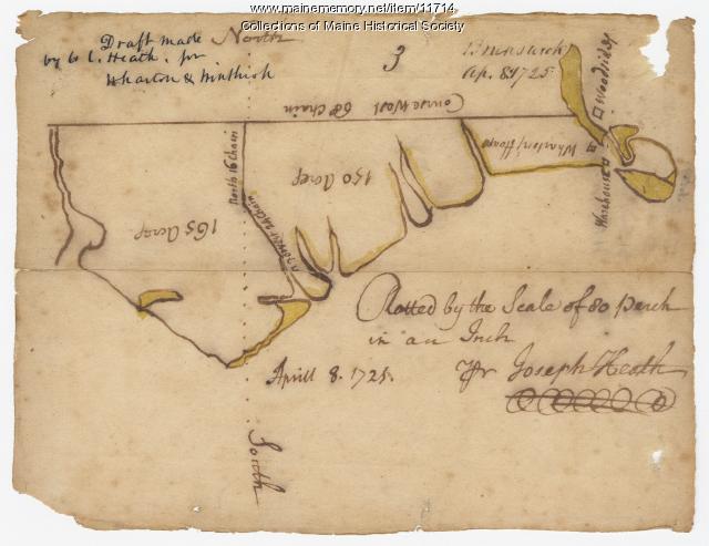
Contributed by: Maine Historical Society Date: 1725-04-08 Location: Brunswick Media: Ink on paper
Item 11717

Contributed by: Maine Historical Society Date: circa 1718 Location: Brunswick; Harpswell; Bath; Topsham Media: Ink on paper
Item 11718

Contributed by: Maine Historical Society Date: circa 1740 Location: Brunswick Media: Ink on paper
Item 11721

Plan of Land at Brunswick Narrows, 1741
Contributed by: Maine Historical Society Date: 1741 Location: Brunswick Media: Ink on paper
Item 11722

Map of Brunswick, lots on Merrymeeting Bay, ca. 1750
Contributed by: Maine Historical Society
Date: circa 1750
Location: Brunswick
Media: Ink on paper
This record contains 2 images.
Item 11724

Map of Brunswick near the Narrows, 1737
Contributed by: Maine Historical Society
Date: 1737
Location: Brunswick; Topsham
Media: Ink on paper
This record contains 2 images.
Item 11726

Contributed by: Maine Historical Society
Date: 1795-05-29
Location: Brunswick; Durham; Freeport; Bath
Media: Ink on paper
This record contains 2 images.
Item 11728

Plan of a road in Brunswick, 1764
Contributed by: Maine Historical Society Date: 1764 Location: Brunswick; Bath Media: Ink on paper
Item 11739
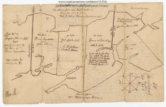
Contributed by: Maine Historical Society Date: 1771-06-17 Location: Harpswell Media: Ink on paper
Item 11743

Contributed by: Maine Historical Society Date: 1742-11-12 Location: Harpswell Media: Ink on paper
Item 11752

Contributed by: Maine Historical Society Date: circa 1760 Location: North Yarmouth Media: Ink on paper
Item 11757

John Robinson lot, Topsham, 1761
Contributed by: Maine Historical Society Date: 1761 Location: Topsham Media: Ink on paper
Item 11834

Map showing Monument and Glendenning Brooks, 1924
Contributed by: Maine Historical Society Date: 1924 Media: Ink on paper, map
Item 11923

Survey of Robert and John Donlop lots, Brunswick, 1757
Contributed by: Maine Historical Society Date: 1757 Location: Brunswick Media: Ink on paper
Item 11924

Lots on Maquoit Road, Brunswick, 1761
Contributed by: Maine Historical Society Date: 1761 Location: Brunswick Media: Ink on paper
Item 11928

Fulton and Patten lots in Bowdoinham, 1759
Contributed by: Maine Historical Society
Date: 1759
Location: Bowdoinham
Media: Ink on paper
This record contains 2 images.
