Keywords: town maps
- Historical Items (337)
- Tax Records (0)
- Architecture & Landscape (25)
- Online Exhibits (25)
- Site Pages (168)
- My Maine Stories (3)
- Lesson Plans (0)
Historical Items
These results include photographs, documents, letters, paintings, artifacts, and many other kinds of Maine related items from collections around the state and elsewhere.
Item 5957

William Patten's land, Topsham, 1771
Contributed by: Maine Historical Society Date: 1771-04-12 Location: Bowdoinham Media: Ink on paper
Item 11749

Contributed by: Maine Historical Society Date: circa 1760 Location: Durham Media: Ink on paper
Item 11751

North Yarmouth road, Yarmouth, ca. 1760
Contributed by: Maine Historical Society Date: circa 1760 Location: Yarmouth Media: Ink on paper
Item 68871

Second parish of Scarborough, 1798
Contributed by: Maine Historical Society Date: 1798 Location: Scarborough Media: Ink on paper
Item 6885

Plan of James Deering's Farm, Portland, 1843
Contributed by: Maine Historical Society Date: 1843 Location: Portland Media: Ink on paper
Item 11719
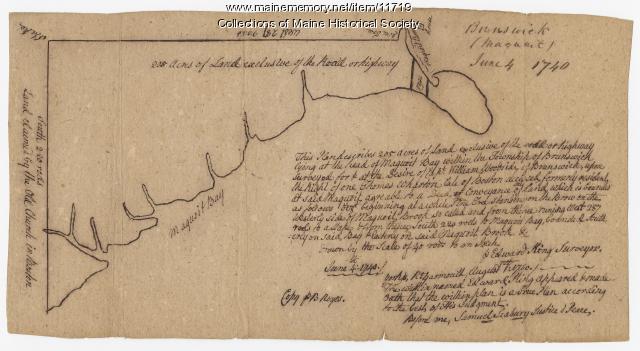
Contributed by: Maine Historical Society Date: 1740-06-04 Location: Brunswick Media: Ink on paper
Item 11729

Land surveyed for Hugh Wilson, Topsham, 1761
Contributed by: Maine Historical Society Date: 1761-01-01 Location: Topsham Media: Ink on paper
Item 5958

Acter Patten's land, Topsham, 1765
Contributed by: Maine Historical Society Date: 1765-11-09 Location: Topsham Media: Ink on paper
Item 12855

Plan of Cumberland and Lincoln counties, 1773
Contributed by: Maine Historical Society
Date: 1773
Media: Ink on paper
This record contains 2 images.
Item 12936

Plan for the house of worship, Pownalborough, 1760
Contributed by: Maine Historical Society
Date: 1760-12-12
Location: Dresden
Media: Ink on paper
This record contains 2 images.
Item 108722

Birds-eye view of the cities of Biddeford & Saco, 1875
Contributed by: Maine Historical Society Date: 1875 Location: Biddeford; Saco Media: ink on paper
Item 11748

Joshua Scottow's land boundary, Brunswick, 1737
Contributed by: Maine Historical Society Date: 1737-06-24 Location: Brunswick Media: Ink on paper
Item 68914

Samuel Calf's land, Scarborough, 1786
Contributed by: Maine Historical Society Date: 1786 Location: Scarborough Media: Ink on paper
Item 11979

Norridgewock Fort and Kennebec River, 1719
Contributed by: Maine Historical Society
Date: 1719
Location: Norridgewock
Media: Ink on paper
This record contains 2 images.
Item 11727

Cathance Millright's land, Topsham, 1759
Contributed by: Maine Historical Society Date: 1759-06-16 Location: Topsham Media: Ink on paper
Item 11746

Contributed by: Maine Historical Society Date: 1749-07-04 Location: Brunswick; Harpswell Media: Ink on paper
Item 11927

Thomas Wilson lot, Topsham, 1764
Contributed by: Maine Historical Society Date: 1764 Location: Topsham Media: Ink on paper
Item 25025

Luke Lambard to U.S. Marshall Thornton about 1820 census, Bath, 1820
Contributed by: Maine Historical Society Date: 1820 Location: Georgetown; Woolwich; Dresden Media: Ink on paper
Item 12562

Part of the Pownalborough plan, Augusta and Dresden, ca. 1760
Contributed by: Maine Historical Society
Date: circa 1760
Location: Augusta; Dresden; Pittston; Randolph; Alna
Media: Ink on paper
This record contains 2 images.
Item 35626

Bird's-eye view of Deering, 1886
Contributed by: Maine Historical Society Date: 1886 Location: Portland Media: Ink on paper, lithograph
Item 100353

Bird's eye view of the city of Lewiston & Auburn, 1876
Contributed by: Maine Historical Society Date: 1876 Location: Lewiston; Auburn Media: Ink on paper
Item 5320

Peletiah Haly's lot, Haly's Island, ca. 1750
Contributed by: Maine Historical Society Date: circa 1750 Location: Topsham; Brunswick Media: Ink on paper
Item 108725

Bird's eye view of Castine, 1889
Contributed by: Maine Historical Society Date: 1889 Location: Castine Media: ink on paper
Item 108728

Bird's eye view of West Waterville (Oakland), 1878
Contributed by: Maine Historical Society Date: 1878 Location: West Waterville; Oakland Media: lithograph
