Keywords: Real property.
- Historical Items (361)
- Tax Records (19147)
- Architecture & Landscape (8)
- Online Exhibits (21)
- Site Pages (105)
- My Maine Stories (4)
- Lesson Plans (0)
Historical Items
These results include photographs, documents, letters, paintings, artifacts, and many other kinds of Maine related items from collections around the state and elsewhere.
Item 108750

Contributed by: Maine Historical Society
Date: 1834-10-02
Location: Leeds
Media: Ink on paper
This record contains 3 images.
Item 108751

50 acres bargained, Leeds, 1834
Contributed by: Maine Historical Society
Date: 1834-10-02
Location: Leeds
Media: Ink on paper
This record contains 3 images.
Item 108752

Plan of William Libby's lot, Durham, 1819
Contributed by: Maine Historical Society Date: 1819-12-08 Location: Durham Media: Ink on paper
Item 108754

Plan excepting a road to Durham, 1821
Contributed by: Maine Historical Society Date: 1821-06-29 Location: Durham Media: Ink on paper
Item 108755

Land of Samuel Sylvester, Prout's Gore, 1813
Contributed by: Maine Historical Society Date: 1813-11-05 Location: Freeport Media: Ink on paper
Item 108756

Plot adjacent to Peables' fence, ca. 1800
Contributed by: Maine Historical Society Date: circa 1800 Media: Ink on paper
Item 108757

Survey of land eastern side of No Name Pond, Lewiston, ca. 1800
Contributed by: Maine Historical Society
Date: circa 1800
Location: Lewiston
Media: Ink on paper
This record contains 2 images.
Item 108758

Survey of part of lot 155, 1841
Contributed by: Maine Historical Society Date: 1841-06-17 Media: Ink on paper
Item 108759

Survey of land in Poland, 1842
Contributed by: Maine Historical Society Date: 1842 Location: Poland Media: Ink on paper
Item 109026

Abagadassat Mill lots, Bowdoinham, 1755
Contributed by: Maine Historical Society
Date: 1755
Location: Bowdoinham
Media: Ink on paper
This record contains 2 images.
Item 148977

Map of Dead River Plantation, ca. 1915
Contributed by: Maine Historical Society Date: circa 1915 Location: Dead River Plantation Media: Ink on linen
Item 148979

Map of Township 8, Range 11, ca. 1915
Contributed by: Maine Historical Society Date: circa 1915 Location: T8 R11 WELS Media: Ink on linen
Item 148980

Map of Township 10 Range 8, ca. 1915
Contributed by: Maine Historical Society Date: circa 1915 Location: T10 R8 Media: Ink on linen
Item 36073

Baldwin deed to Phebe Sanborn, 1859
Contributed by: Maine Historical Society Date: 1859 Location: Baldwin Media: Ink on paper
Item 5320

Peletiah Haly's lot, Haly's Island, ca. 1750
Contributed by: Maine Historical Society Date: circa 1750 Location: Topsham; Brunswick Media: Ink on paper
Item 5330

The Pejepscot Claim, September 15, 1764
Contributed by: Maine Historical Society Date: 1764-09-15 Location: Brunswick; Topsham; Freeport; Harpswell; Lewiston; North Yarmouth Media: Ink on paper
Item 5890

Sara Cotta's lot, Brunswick, 1731
Contributed by: Maine Historical Society Date: 1731 Location: Brunswick Media: Ink on paper
Item 5958

Acter Patten's land, Topsham, 1765
Contributed by: Maine Historical Society Date: 1765-11-09 Location: Topsham Media: Ink on paper
Item 10067

Contributed by: Maine Historical Society Date: circa 1780 Location: Gray Media: Ink on paper
Item 11923

Survey of Robert and John Donlop lots, Brunswick, 1757
Contributed by: Maine Historical Society Date: 1757 Location: Brunswick Media: Ink on paper
Item 11924

Lots on Maquoit Road, Brunswick, 1761
Contributed by: Maine Historical Society Date: 1761 Location: Brunswick Media: Ink on paper
Item 11925

Seven lots on the Androscoggin River, 1771
Contributed by: Maine Historical Society Date: 1771 Location: Brunswick; Topsham; Freeport; Durham Media: Ink on paper
Item 11926
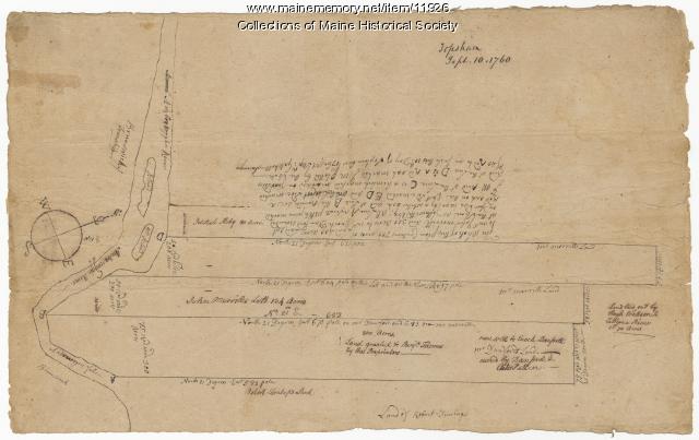
Morrill and Danforth lots, Topsham, 1760
Contributed by: Maine Historical Society
Date: 1760-09-10
Location: Topsham
Media: Ink on paper
This record contains 2 images.
Item 11929
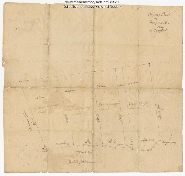
Flying Point at Maquoit Bay, Freeport, ca. 1770
Contributed by: Maine Historical Society Date: circa 1770 Location: Freeport; Brunswick Media: Ink on paper
