Keywords: Manuscript map
- Historical Items (364)
- Tax Records (0)
- Architecture & Landscape (0)
- Online Exhibits (9)
- Site Pages (96)
- My Maine Stories (0)
- Lesson Plans (0)
Historical Items
These results include photographs, documents, letters, paintings, artifacts, and many other kinds of Maine related items from collections around the state and elsewhere.
Item 108837

Copy of Thomas Johnston's Plan of part of the Eastern Shore, ca. 1770
Contributed by: Maine Historical Society
Date: 1753
Media: Ink on paper
This record contains 2 images.
Item 110895

Plan of the islands at the mouth of the River St. Clair, ca. 1823
Contributed by: Maine Historical Society
Date: circa 1823
Media: Ink on paper
This record contains 3 images.
Item 11730

Contributed by: Maine Historical Society Date: 1761-11-12 Location: Topsham Media: Ink on paper
Item 11743

Contributed by: Maine Historical Society Date: 1742-11-12 Location: Harpswell Media: Ink on paper
Item 11965

Contributed by: City of Portland Dept. of Public Works Date: 1773 Location: Portland Media: Ink on paper, map
Item 11739
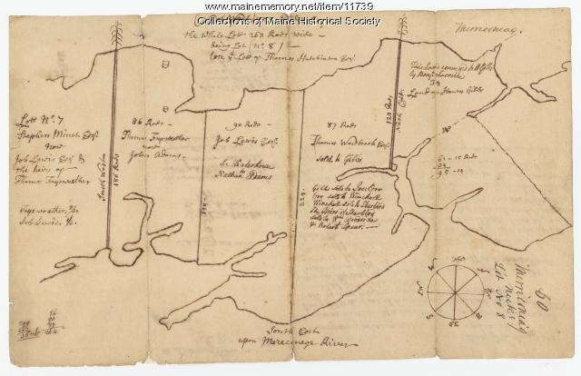
Contributed by: Maine Historical Society Date: 1771-06-17 Location: Harpswell Media: Ink on paper
Item 11726

Contributed by: Maine Historical Society
Date: 1795-05-29
Location: Brunswick; Durham; Freeport; Bath
Media: Ink on paper
This record contains 2 images.
Item 11714
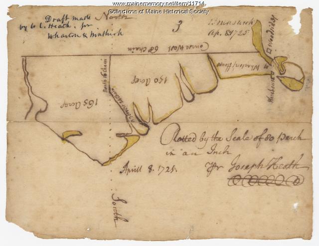
Contributed by: Maine Historical Society Date: 1725-04-08 Location: Brunswick Media: Ink on paper
Item 109022

Disputed lot E, Brunswick, 1811
Contributed by: Maine Historical Society
Date: 1811-09-03
Location: Brunswick
Media: Ink on paper
This record contains 3 images.
Item 116498

Manuscript survey of Lac La Croix, Vermillion Lake, ca. 1820
Contributed by: Maine Historical Society
Date: circa 1820
Media: Ink on paper
This record contains 2 images.
Item 7494

Map of New England and New York, ca. 1676
Contributed by: Maine Historical Society Date: circa 1676 Media: Ink on paper
Item 12398

Early map of the Sheepscot River, 1816
Contributed by: Maine Historical Society
Date: 1816-01-08
Location: Somerville; Whitefield; Windsor
Media: Ink on paper
This record contains 2 images.
Item 11741

Contributed by: Maine Historical Society Date: 1742 Location: Harpswell Media: Ink on paper
Item 12396

Androscoggin River area map, 1771
Contributed by: Maine Historical Society
Date: 1771-06-11
Location: Jay; Canton; Livermore Falls
Media: Ink on paper
This record contains 2 images.
Item 12196

Map of Kennebec Purchase lots, ca. 1750
Contributed by: Maine Historical Society
Date: circa 1750
Media: Ink on paper
This record contains 2 images.
Item 20766

Manuscript Map of Moose River, Moosehead Lake, and Kennebeck Road, 1820
Contributed by: Maine Historical Society Date: 1820 Media: Ink on paper
Item 11732

Contributed by: Maine Historical Society Date: circa 1760 Location: Topsham Media: Ink on paper
Item 11725

Contributed by: Maine Historical Society Date: 1772 Location: Brunswick Media: Ink on paper
Item 11963
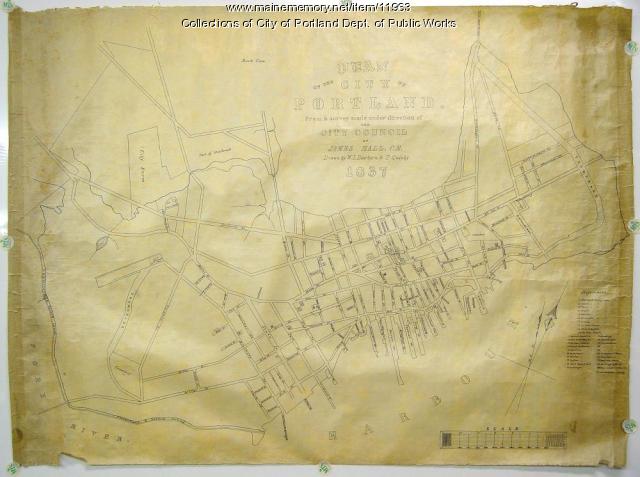
Plan of the City of Portland, 1837
Contributed by: City of Portland Dept. of Public Works Date: 1837 Location: Portland Media: Ink on paper, map
Item 11724

Map of Brunswick near the Narrows, 1737
Contributed by: Maine Historical Society
Date: 1737
Location: Brunswick; Topsham
Media: Ink on paper
This record contains 2 images.
Item 12125

Map of Cobbosseecontee Stream, 1765
Contributed by: Maine Historical Society
Date: 1765-07-29
Location: Augusta; Gardiner; Farmingdale; Hallowell; Litchfield; Manchester; Winthrop; Monmouth
Media: Ink on paper
This record contains 2 images.
Item 110903

Contributed by: Maine Historical Society
Date: circa 1823
Location: Cornwall ; Cornwall Island
Media: Ink on paper
This record contains 2 images.
Item 10762

Enclosure map, Stroudwater, 1756
Contributed by: Maine Historical Society Date: 1756 Location: Portland; Westbrook Media: Ink on paper
Item 7493

Nova Anglia Septentrionali, ca. 1759
Contributed by: Maine Historical Society Date: circa 1720 Media: Map ink on paper
