Keywords: Pejepscot River
- Historical Items (155)
- Tax Records (0)
- Architecture & Landscape (0)
- Online Exhibits (13)
- Site Pages (88)
- My Maine Stories (0)
- Lesson Plans (0)
Historical Items
These results include photographs, documents, letters, paintings, artifacts, and many other kinds of Maine related items from collections around the state and elsewhere.
Item 11732

Contributed by: Maine Historical Society Date: circa 1760 Location: Topsham Media: Ink on paper
Item 4316

Plan of J. Robinson lot, Topsham, 1761
Contributed by: Maine Historical Society Date: 1761 Location: Topsham Media: Ink on paper
Item 10568

Pejepscot Dam, Topsham, from abutment, 1896
Contributed by: Maine Historical Society Date: 1896-11-07 Location: Topsham Media: Photographic print
Item 10565

Team of oxen at Pejepscot Paper Co. dam site, Topsham, 1893
Contributed by: Maine Historical Society Date: 1893-04-14 Location: Topsham Media: Photographic print
Item 11723

Contributed by: Maine Historical Society Date: 1747-07-06 Location: Brunswick Media: Ink on paper
Item 11727

Cathance Millright's land, Topsham, 1759
Contributed by: Maine Historical Society Date: 1759-06-16 Location: Topsham Media: Ink on paper
Item 11729

Land surveyed for Hugh Wilson, Topsham, 1761
Contributed by: Maine Historical Society Date: 1761-01-01 Location: Topsham Media: Ink on paper
Item 4324

Androscoggin and Kennebec Rivers, ca. 1755
Contributed by: Maine Historical Society Date: circa 1755 Media: Ink on paper
Item 11731

William Patten's lot, Topsham, 1761
Contributed by: Maine Historical Society Date: 1761-11-24 Location: Topsham Media: Ink on paper
Item 10561

Preparing for dam, Pejepscot Paper Co., Topsham, 1893
Contributed by: Maine Historical Society Date: 1893-04-14 Location: Topsham Media: Photographic print
Item 11725

Contributed by: Maine Historical Society Date: 1772 Location: Brunswick Media: Ink on paper
Item 4323
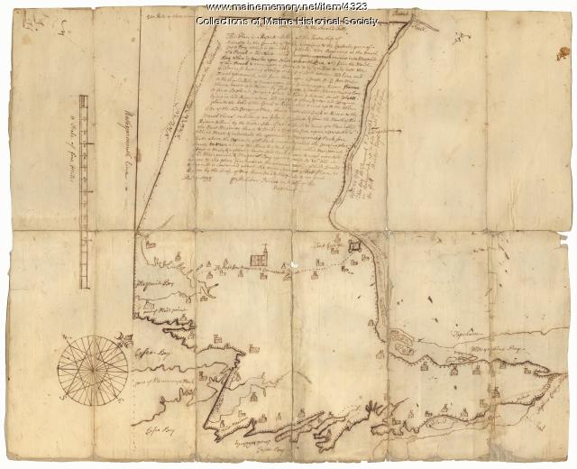
Contributed by: Maine Historical Society
Date: 1738
Location: Brunswick; Harpswell; Topsham
Media: Ink on paper
This record contains 2 images.
Item 10570

Workers at Pejepscot Paper Company, Topsham, ca. 1900
Contributed by: Maine Historical Society Date: circa 1900 Location: Topsham Media: Photographic print
Item 5960

Fort land for William Ross, Brunswick, ca. 1763
Contributed by: Maine Historical Society Date: circa 1763 Location: Brunswick Media: Ink on paper
Item 10562
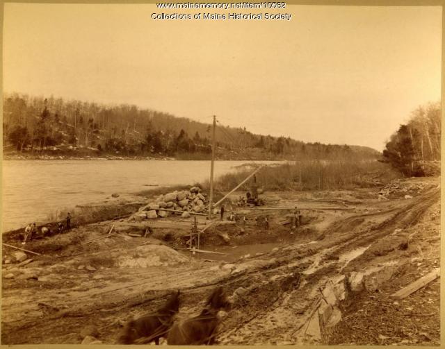
Overview of dam site, Pejepscot Paper Co., Topsham, 1893
Contributed by: Maine Historical Society Date: 1893-04-14 Location: Topsham Media: Photographic print
Item 10560

Construction of dam, Pejepscot Paper Co., Topsham, 1893
Contributed by: Maine Historical Society Date: 1893-06-15 Location: Topsham Media: Photographic print
Item 20489

Androscoggin River flood, September 1987
Contributed by: Pejepscot History Center Date: 1987 Location: Topsham Media: Photographic print
Item 11736

Lots on Cathance River, Topsham, 1764
Contributed by: Maine Historical Society Date: 1764-02-28 Location: Topsham Media: Ink on paper
Item 66378

Topsham-Brunswick Bridge, Brunswick, ca. 1938
Contributed by: Boston Public Library Date: circa 1938 Location: Brunswick; Topsham Media: Linen texture postcard
Item 11979

Norridgewock Fort and Kennebec River, 1719
Contributed by: Maine Historical Society
Date: 1719
Location: Norridgewock
Media: Ink on paper
This record contains 2 images.
Item 4319

Contributed by: Maine Historical Society Date: circa 1795 Location: Freeport; New Gloucester; Brunswick Media: Ink on paper
Item 108760

Survey of lots near Great and Little Androscoggin Rivers, ca. 1800
Contributed by: Maine Historical Society Date: circa 1800 Media: Ink on paper
Item 20572

Contributed by: Pejepscot History Center Date: circa 1900 Location: Brunswick Media: Photographic print
Item 102069

Early map of Lewiston, Auburn and Minot, 1820
Contributed by: Maine Historical Society
Date: 1820
Location: Lewiston; Auburn; Minot
Media: Ink on paper
This record contains 2 images.
