Keywords: Roads -- Maine -- Maps
- Historical Items (154)
- Tax Records (0)
- Architecture & Landscape (51)
- Online Exhibits (23)
- Site Pages (63)
- My Maine Stories (4)
- Lesson Plans (0)
Historical Items
These results include photographs, documents, letters, paintings, artifacts, and many other kinds of Maine related items from collections around the state and elsewhere.
Item 100777

Plan of North End of Bangor, 1844
Contributed by: Maine Historical Society and Maine State Museum Date: 1844-03-11 Location: Bangor Media: Ink and watercolor on paper
Item 4173

Contributed by: Maine Historical Society Date: 1866 Location: Portland Media: Ink on paper
Item 176

Plan of Portland, engraved as a directory, 1852
Contributed by: Maine Historical Society Date: 1852 Location: Portland Media: Ink on paper
Item 22212

Contributed by: Aroostook County Historical and Art Museum Date: circa 1870 Location: Houlton Media: Ink on paper
Item 11924

Lots on Maquoit Road, Brunswick, 1761
Contributed by: Maine Historical Society Date: 1761 Location: Brunswick Media: Ink on paper
Item 22215
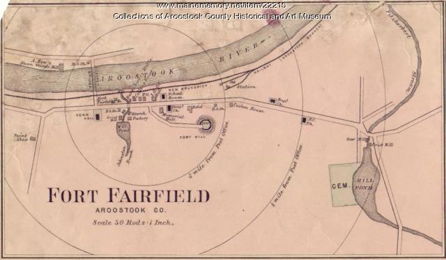
Map of Fort Fairfield, ca. 1870
Contributed by: Aroostook County Historical and Art Museum Date: circa 1870 Location: Fort Fairfield Media: Ink on paper
Item 108754

Plan excepting a road to Durham, 1821
Contributed by: Maine Historical Society Date: 1821-06-29 Location: Durham Media: Ink on paper
Item 102252

Plan of burial ground, Minot, ca. 1835
Contributed by: Maine Historical Society Date: 1835 Location: Minot Media: Ink on paper
Item 4171

Contributed by: Maine Historical Society Date: 1866-07-04 Location: Portland Media: Ink on paper
Item 148742

Timber map of the west half of T9 R3, 1938
Contributed by: Maine Historical Society Date: 1938 Location: T9 R3 WELS Media: Ink on linen; hand coloring
Item 11750

Contributed by: Maine Historical Society Date: 1770 Location: Durham Media: Ink on paper
Item 111036

Contributed by: Maine Historical Society Date: circa 1820 Media: Ink on paper
Item 11752

Contributed by: Maine Historical Society Date: circa 1760 Location: North Yarmouth Media: Ink on paper
Item 4175

Plan of the City of Portland, 1837
Contributed by: Maine Historical Society Date: 1837 Location: Portland Media: Paper
Item 102070

Early map of Lewiston, Auburn and Minot, ca. 1820
Contributed by: Maine Historical Society Date: circa 1820 Location: Auburn; Lewiston; Minot Media: Ink on paper
Item 11751

North Yarmouth road, Yarmouth, ca. 1760
Contributed by: Maine Historical Society Date: circa 1760 Location: Yarmouth Media: Ink on paper
Item 59772

Electric railroad route map, ca. 1933
Contributed by: Seashore Trolley Museum Date: circa 1933 Location: Portland; Falmouth; Yarmouth; Cumberland Media: Ink on paper
Item 6893

A new and correct plan of Portland, 1823
Contributed by: Maine Historical Society Date: 1823 Location: Portland Media: Ink on paper
Item 22216

Contributed by: Aroostook County Historical and Art Museum Date: circa 1870 Location: Presque Isle Media: Ink on paper
Item 11925

Seven lots on the Androscoggin River, 1771
Contributed by: Maine Historical Society Date: 1771 Location: Brunswick; Topsham; Freeport; Durham Media: Ink on paper
Item 108760

Survey of lots near Great and Little Androscoggin Rivers, ca. 1800
Contributed by: Maine Historical Society Date: circa 1800 Media: Ink on paper
Item 74772

Electric rural road survey, Boothbay, 1929
Contributed by: Maine Historical Society Date: 1929 Location: Boothbay; Edgecomb Media: Ink on paper
Item 108722

Birds-eye view of the cities of Biddeford & Saco, 1875
Contributed by: Maine Historical Society Date: 1875 Location: Biddeford; Saco Media: ink on paper
Item 149659

Map for Martin's Sporting Camps, Sinclair, 1953
Contributed by: Acadian Archives Date: 1953 Location: Square Lake Media: Postcard
