LC Subject Heading: Maine -- Maps, Manuscript.
- Historical Items (64)
- Tax Records (0)
- Architecture & Landscape (0)
- Online Exhibits (0)
- Site Pages (0)
- My Maine Stories (0)
- Lesson Plans (0)
Historical Items
These results include photographs, documents, letters, paintings, artifacts, and many other kinds of Maine related items from collections around the state and elsewhere.
Item 105015

Figure de la Terre Neuve, grande riviere de Canada, et cotes de l'ocean en la Nouvelle France, 1618
Contributed by: Maine Historical Society Date: 1607 Media: Ink on paper
Item 108853

A plan of a survey of sundry settlers' lots in Sheepscut Great Pond Settlement, 1802
Contributed by: Maine Historical Society Date: circa 1802 Location: Palermo Media: ink on paper
Item 110981

Contributed by: Maine Historical Society Date: 1817–1820 Media: Ink on paper
Item 6883

St. John and Penobscot Rivers map, 1798
Contributed by: Maine Historical Society Date: 1798-05-08 Location: Pleasant Point Media: Ink on paper
Item 9259

Early map of the Salmon Falls River in Lebanon, 1766
Contributed by: Maine Historical Society Date: 1766 Location: Lebanon Media: Ink on paper
Item 11727

Cathance Millright's land, Topsham, 1759
Contributed by: Maine Historical Society Date: 1759-06-16 Location: Topsham Media: Ink on paper
Item 11729

Land surveyed for Hugh Wilson, Topsham, 1761
Contributed by: Maine Historical Society Date: 1761-01-01 Location: Topsham Media: Ink on paper
Item 11730

Contributed by: Maine Historical Society Date: 1761-11-12 Location: Topsham Media: Ink on paper
Item 11731

William Patten's lot, Topsham, 1761
Contributed by: Maine Historical Society Date: 1761-11-24 Location: Topsham Media: Ink on paper
Item 11732

Contributed by: Maine Historical Society Date: circa 1760 Location: Topsham Media: Ink on paper
Item 11733

Noyes, Skinner, and Merrill lots, Topsham, 1762
Contributed by: Maine Historical Society Date: 1762-01-05 Location: Topsham Media: Ink on paper
Item 11734

Hugh Wilson property, Topsham, 1762
Contributed by: Maine Historical Society Date: 1762-03-04 Location: Topsham Media: Ink on paper
Item 11735

Samuel Wilson lot, Topsham, 1762
Contributed by: Maine Historical Society Date: 1762 Location: Topsham Media: Ink on paper
Item 11736

Lots on Cathance River, Topsham, 1764
Contributed by: Maine Historical Society Date: 1764-02-28 Location: Topsham Media: Ink on paper
Item 11737
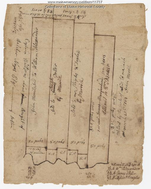
Contributed by: Maine Historical Society Date: 1764-04-07 Location: Topsham Media: Ink on paper
Item 11739
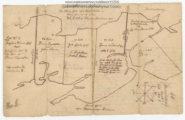
Contributed by: Maine Historical Society Date: 1771-06-17 Location: Harpswell Media: Ink on paper
Item 11741

Contributed by: Maine Historical Society Date: 1742 Location: Harpswell Media: Ink on paper
Item 11746

Contributed by: Maine Historical Society Date: 1749-07-04 Location: Brunswick; Harpswell Media: Ink on paper
Item 11748

Joshua Scottow's land boundary, Brunswick, 1737
Contributed by: Maine Historical Society Date: 1737-06-24 Location: Brunswick Media: Ink on paper
Item 11751

North Yarmouth road, Yarmouth, ca. 1760
Contributed by: Maine Historical Society Date: circa 1760 Location: Yarmouth Media: Ink on paper
Item 11752

Contributed by: Maine Historical Society Date: circa 1760 Location: North Yarmouth Media: Ink on paper
Item 11754

Plan for towns along the Androscoggin River, ca. 1760
Contributed by: Maine Historical Society Date: circa 1760 Location: Livermore Falls; Canton; Mexico; Jay; Leeds Media: Ink on paper
Item 11757

John Robinson lot, Topsham, 1761
Contributed by: Maine Historical Society Date: 1761 Location: Topsham Media: Ink on paper
Item 13074

Manuscript map of Kennebec River area, 1771
Contributed by: Maine Historical Society Date: 1771 Media: Ink on paper
