Keywords: early maps
- Historical Items (263)
- Tax Records (0)
- Architecture & Landscape (0)
- Online Exhibits (29)
- Site Pages (128)
- My Maine Stories (7)
- Lesson Plans (0)
Historical Items
These results include photographs, documents, letters, paintings, artifacts, and many other kinds of Maine related items from collections around the state and elsewhere.
Item 11731

William Patten's lot, Topsham, 1761
Contributed by: Maine Historical Society Date: 1761-11-24 Location: Topsham Media: Ink on paper
Item 9166

Contributed by: Maine Historical Society Date: 1795 Media: Ink on paper
Item 4168

Contributed by: Maine Historical Society Date: 1690 Location: Portland Media: Ink on paper
Item 11729

Land surveyed for Hugh Wilson, Topsham, 1761
Contributed by: Maine Historical Society Date: 1761-01-01 Location: Topsham Media: Ink on paper
Item 12398

Early map of the Sheepscot River, 1816
Contributed by: Maine Historical Society Date: 1816-01-08 Location: Somerville; Whitefield; Windsor Media: Ink on paper
Item 11720

Contributed by: Maine Historical Society Date: 1740-09-29 Location: Brunswick Media: Ink on paper
Item 31237

Moses Banks Map, Scarborough, 1787
Contributed by: Scarborough Historical Society & Museum Date: 1787 Location: Scarborough Media: Paper and ink
Item 68872

Plan of farm, Scarborough, 1741
Contributed by: Maine Historical Society Date: 1741 Location: Cape Elizabeth Media: Ink on paper
Item 109000

Dresden and Woolwich proposed border, ca. 1757
Contributed by: Maine Historical Society Date: circa 1757 Location: Woolwich; Dresden Media: Ink on paper
Item 22383

Contributed by: Maine Historical Society Date: 1727 Location: North Yarmouth; Falmouth; Freeport Media: Ink on paper
Item 5960

Fort land for William Ross, Brunswick, ca. 1763
Contributed by: Maine Historical Society Date: circa 1763 Location: Brunswick Media: Ink on paper
Item 7540

Map of the New England Coast, 1610
Contributed by: Maine Historical Society Date: 1610 Media: Ink on paper
Item 12851

Contributed by: Maine Historical Society Date: 1798 Media: Ink on paper
Item 11727

Cathance Millright's land, Topsham, 1759
Contributed by: Maine Historical Society Date: 1759-06-16 Location: Topsham Media: Ink on paper
Item 11743

Contributed by: Maine Historical Society Date: 1742-11-12 Location: Harpswell Media: Ink on paper
Item 5330

The Pejepscot Claim, September 15, 1764
Contributed by: Maine Historical Society Date: 1764-09-15 Location: Brunswick; Topsham; Freeport; Harpswell; Lewiston; North Yarmouth Media: Ink on paper
Item 11739
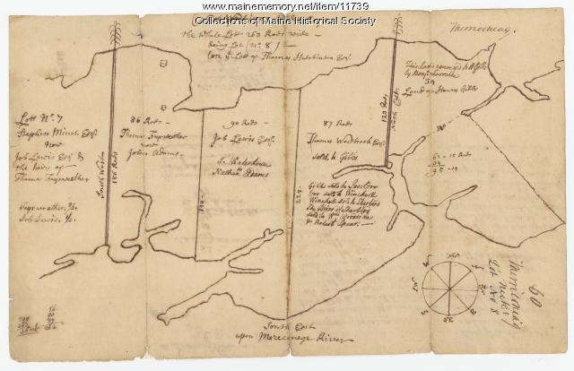
Contributed by: Maine Historical Society Date: 1771-06-17 Location: Harpswell Media: Ink on paper
Item 11723

Contributed by: Maine Historical Society Date: 1747-07-06 Location: Brunswick Media: Ink on paper
Item 109025

Manuscript map of Topsham Lots, 1763
Contributed by: Maine Historical Society Date: 1763 Location: Topsham Media: Ink on paper
Item 5958

Acter Patten's land, Topsham, 1765
Contributed by: Maine Historical Society Date: 1765-11-09 Location: Topsham Media: Ink on paper
Item 68865

Contributed by: Maine Historical Society Date: 1784 Location: Scarborough Media: Ink on paper
Item 5957

William Patten's land, Topsham, 1771
Contributed by: Maine Historical Society Date: 1771-04-12 Location: Bowdoinham Media: Ink on paper
Item 11714
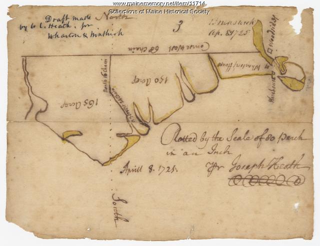
Contributed by: Maine Historical Society Date: 1725-04-08 Location: Brunswick Media: Ink on paper
Item 10762

Enclosure map, Stroudwater, 1756
Contributed by: Maine Historical Society Date: 1756 Location: Portland; Westbrook Media: Ink on paper
