Keywords: town maps
- Historical Items (337)
- Tax Records (0)
- Architecture & Landscape (25)
- Online Exhibits (25)
- Site Pages (168)
- My Maine Stories (3)
- Lesson Plans (0)
Historical Items
These results include photographs, documents, letters, paintings, artifacts, and many other kinds of Maine related items from collections around the state and elsewhere.
Item 31883

Map of Cumberland County, 1880
Contributed by: North Yarmouth Historical Society Date: 1880 Media: Ink on paper
Item 28457

Roe and Colby map detail, Bath, 1873
Contributed by: Patten Free Library Date: 1873 Location: Bath Media: Ink on paper, linen backed
Item 108837

Copy of Thomas Johnston's Plan of part of the Eastern Shore, ca. 1770
Contributed by: Maine Historical Society
Date: 1753
Media: Ink on paper
This record contains 2 images.
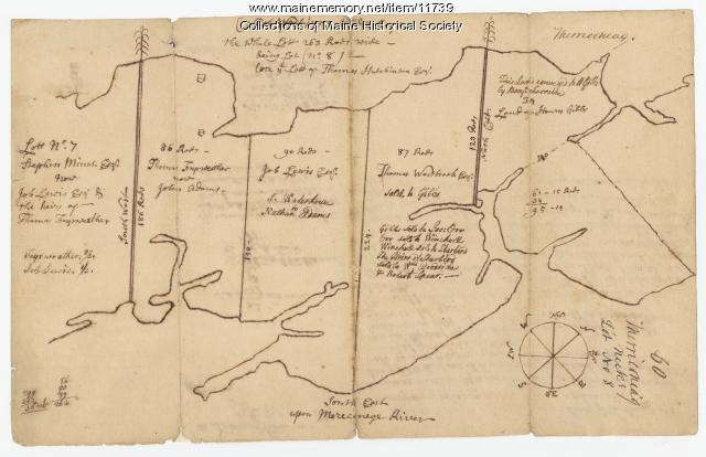
Item 12937
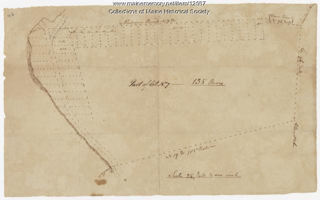
Map of lot no. 7, 135 acres on Madison Road, Skowhegan, ca. 1760
Contributed by: Maine Historical Society
Date: circa 1760
Location: Skowhegan
Media: Ink on paper
This record contains 2 images.
Item 100725

Contributed by: Maine Historical Society Date: 1858 Location: Portland Media: Lithograph with hand-coloring
Item 11779

Plan of a section of Portland called The Oaks, ca. 1845
Contributed by: Maine Historical Society Date: circa 1845 Location: Portland Media: Ink on paper, map
Item 68866

Libby River land, Scarborough, 1794
Contributed by: Maine Historical Society Date: 1794 Location: Scarborough Media: Ink on paper, map
Item 4174

Map of Portland and vicinity, 1900
Contributed by: Maine Historical Society Date: 1900 Location: Portland Media: Paper
Item 13134

Saccarappa and Cumberland Mills panorama, 1879
Contributed by: Maine Historical Society Date: circa 1879 Location: Westbrook Media: lithograph
Item 105433

"Falmouth Neck, as it was when destroyed by Mowett," 1831
Contributed by: Osher Map Library and Smith Center for Cartographic Education Date: 1775-10-18 Location: Portland Media: Lithograph
Item 58322

Copy of early Surry map, ca. 1880
Contributed by: Maine Historical Society Date: circa 1880 Location: Surry Media: Ink on paper
Item 66609

Map of Mt. Desert Island printed on postcard, ca. 1935
Contributed by: Boston Public Library Date: circa 1935 Location: Mount Desert Island Media: Linen texture postcard
Item 12100

Contributed by: Aroostook County Historical and Art Museum Date: 1887 Location: Houlton Media: Ink on paper
Item 75231

Madawaska Training School farm maps, 1948-1949
Contributed by: Blake Library Special Collections Date: 1948–1949 Location: Fort Kent Media: Text with maps
Item 11726

Contributed by: Maine Historical Society
Date: 1795-05-29
Location: Brunswick; Durham; Freeport; Bath
Media: Ink on paper
This record contains 2 images.
Item 6892

Contributed by: Maine Historical Society Date: 1872 Media: Ink on paper
Item 11964

Map of the City and Harbor of Portland, 1870
Contributed by: City of Portland Dept. of Public Works Date: 1870 Location: Portland Media: Ink on paper, map
Item 100214

Alexander W. Longfellow site drawing, Portland, 1838
Contributed by: Maine Historical Society Date: 1838-10-28 Location: Portland Media: Ink and pencil on paper
Item 22383

Contributed by: Maine Historical Society Date: 1727 Location: North Yarmouth; Falmouth; Freeport Media: Ink on paper
Item 71168

Bird's-eye view of Skowhegan, 1892
Contributed by: Boston Public Library Date: 1892 Location: Skowhegan Media: Ink on paper, lithograph
Item 71164

Contributed by: Boston Public Library Date: 1889 Location: Monson Media: Ink on paper, lithograph
Item 108835

Plan of lots 1-10, Fairfield, 1782
Contributed by: Maine Historical Society
Date: 1782-12-20
Location: Fairfield
Media: Ink on paper
This record contains 2 images.
Item 71167

Bird's-eye view of Sanford, 1889
Contributed by: Boston Public Library Date: 1889 Location: Sanford Media: Ink on paper, lithograph
Item 11739
Contributed by: Maine Historical Society Date: 1771-06-17 Location: Harpswell Media: Ink on paper
