LC Subject Heading: Maps, Early
- Historical Items (113)
- Tax Records (0)
- Architecture & Landscape (0)
- Online Exhibits (0)
- Site Pages (0)
- My Maine Stories (0)
- Lesson Plans (0)
Historical Items
These results include photographs, documents, letters, paintings, artifacts, and many other kinds of Maine related items from collections around the state and elsewhere.
Item 12382

Plan of Kennebeck River, ca. 1765
Contributed by: Maine Historical Society Date: circa 1765 Media: Ink on paper
Item 12397

Dr. Silvester Gardiner's tract, Alna, 1761
Contributed by: Maine Historical Society Date: 1759-12-29 Location: Alna Media: Ink on paper
Item 12561

Lots on Tinkham's Pond, Kennebec Patent, ca. 1800
Contributed by: Maine Historical Society Date: circa 1800 Location: Chelsea; Whitefield Media: Ink on paper
Item 12566

Contributed by: Maine Historical Society Date: 1778 Location: Alna Media: Ink on paper
Item 12936

Plan for the house of worship, Pownalborough, 1760
Contributed by: Maine Historical Society Date: 1760-12-12 Location: Dresden Media: Ink on paper
Item 68913

Scarborough landowners, ca. 1800
Contributed by: Maine Historical Society Date: circa 1800 Location: Scarborough Media: Ink on paper
Item 68914

Samuel Calf's land, Scarborough, 1786
Contributed by: Maine Historical Society Date: 1786 Location: Scarborough Media: Ink on paper
Item 108844

Plan of lots in Georgetown, 1759
Contributed by: Maine Historical Society Date: 1759-03-14 Location: Bath Media: Ink on paper
Item 108846

Contributed by: Maine Historical Society Date: 1760-04-08 Location: West Bath Media: Ink on paper
Item 12941

Plan of the Kennebec River, Nov. 1763
Contributed by: Maine Historical Society Date: 1763 Location: Richmond Media: Ink on paper
Item 11923

Survey of Robert and John Donlop lots, Brunswick, 1757
Contributed by: Maine Historical Society Date: 1757 Location: Brunswick Media: Ink on paper
Item 11926
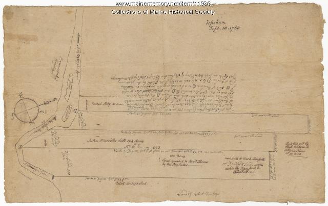
Morrill and Danforth lots, Topsham, 1760
Contributed by: Maine Historical Society Date: 1760-09-10 Location: Topsham Media: Ink on paper
Item 12197
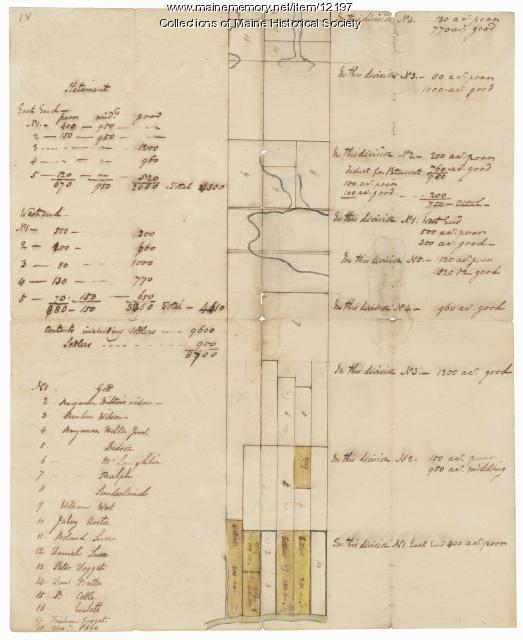
Division of the Tyng and Lowell estates, ca. 1760
Contributed by: Maine Historical Society Date: circa 1760 Media: Ink on paper
Item 12380

Tract granted to Samuel Goodwin, ca. 1757
Contributed by: Maine Historical Society Date: circa 1757 Location: Dresden Media: Ink on paper
Item 12381

Lot No. 39 of the Plymouth Company grant, June 1764
Contributed by: Maine Historical Society Date: 1764-06-27 Location: Winslow Media: Ink on paper
Item 12852

Kennebec River above Fort Western, ca. 1800
Contributed by: Maine Historical Society Date: circa 1800 Media: Ink on paper
Item 68870

Lower part of Scarborough, ca. 1740
Contributed by: Maine Historical Society Date: circa 1740 Location: Scarborough Media: Ink and wash on paper
Item 108858

Plan of 200 acres on the Western Side of Kennebec River, Frankfort Plantation, 1758
Contributed by: Maine Historical Society Date: 1758 Location: Dresden Media: Ink on paper
Item 4182

Plan of Rascoheegan alias Parker's Island, 1759
Contributed by: Maine Historical Society Date: 1759 Location: Georgetown Media: Ink on paper
Item 12854

Contributed by: Maine Historical Society Date: 1719-05-16 Media: Ink on paper
Item 102072

Plan of Royalsborough, ca. 1766
Contributed by: Maine Historical Society Date: circa 1766 Location: Durham Media: Ink on vellum
Item 111012

A Plan of the Rivers Scoodich and Magaguadavic, including the Bay of Passamaquoddy, 1798
Contributed by: Maine Historical Society Date: 1798 Media: Ink on paper
Item 11714
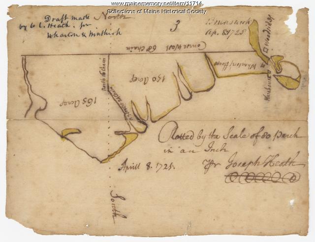
Contributed by: Maine Historical Society Date: 1725-04-08 Location: Brunswick Media: Ink on paper
Item 11717

Contributed by: Maine Historical Society Date: circa 1718 Location: Brunswick; Harpswell; Bath; Topsham Media: Ink on paper
