Keywords: early maps
- Historical Items (266)
- Tax Records (0)
- Architecture & Landscape (0)
- Online Exhibits (29)
- Site Pages (128)
- My Maine Stories (7)
- Lesson Plans (0)
Historical Items
These results include photographs, documents, letters, paintings, artifacts, and many other kinds of Maine related items from collections around the state and elsewhere.
Item 23336

Contributed by: Maine Historical Society Date: 1793 Location: Porter; Brownfield Media: Ink on paper
Item 12396

Androscoggin River area map, 1771
Contributed by: Maine Historical Society Date: 1771-06-11 Location: Jay; Canton; Livermore Falls Media: Ink on paper
Item 11724

Map of Brunswick near the Narrows, 1737
Contributed by: Maine Historical Society Date: 1737 Location: Brunswick; Topsham Media: Ink on paper
Item 68863

Copy of a plan of Black Point, Scarborough, 1741
Contributed by: Maine Historical Society Date: 1741 Location: Scarborough Media: Ink on paper, map
Item 108837

Copy of Thomas Johnston's Plan of part of the Eastern Shore, ca. 1770
Contributed by: Maine Historical Society Date: 1753 Media: Ink on paper
Item 11726

Contributed by: Maine Historical Society Date: 1795-05-29 Location: Brunswick; Durham; Freeport; Bath Media: Ink on paper
Item 12399

Map of Draper's Claim, near Bath, 1795
Contributed by: Maine Historical Society Date: 1795 Media: Ink on paper
Item 10763
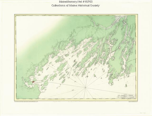
Chart of Casco Bay from the Atlantic Neptune, 1776
Contributed by: Maine Historical Society Date: circa 1776 Media: Ink on paper, map
Item 12196

Map of Kennebec Purchase lots, ca. 1750
Contributed by: Maine Historical Society Date: circa 1750 Media: Ink on paper
Item 5335

Brunswick and Topsham, ca. 1730
Contributed by: Maine Historical Society Date: circa 1730 Location: Brunswick; Topsham Media: Ink on paper
Item 5320

Peletiah Haly's lot, Haly's Island, ca. 1750
Contributed by: Maine Historical Society Date: circa 1750 Location: Topsham; Brunswick Media: Ink on paper
Item 12631

Five farm lots, Bowdoinham, 1718
Contributed by: Maine Historical Society Date: 1718 Location: Bowdoinham Media: Ink on paper
Item 35621
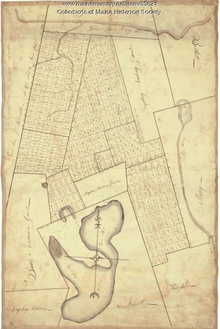
Contributed by: Maine Historical Society Date: circa 1792 Location: Stoneham; Lovell; Bethel; Albany; Mason Twp.; Bachelders Grant Media: Ink on fabric
Item 11719
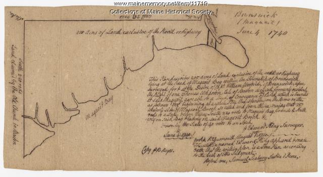
Contributed by: Maine Historical Society Date: 1740-06-04 Location: Brunswick Media: Ink on paper
Item 37702

Contributed by: Maine Historical Society Date: 1764-09-15 Media: Ink on paper
Item 6843

A map of the boundary line explored in 1817
Contributed by: Maine Historical Society Date: 1817 Media: Ink on paper
Item 102073

Map of Lewiston and Auburn, 1851
Contributed by: Maine Historical Society Date: 1851 Location: Lewiston; Auburn Media: Ink on paper
Item 5956

Estate of William Skinner, Topsham, 1766
Contributed by: Maine Historical Society Date: 1766-06-15 Location: Topsham Media: Ink on paper
Item 5343

Contributed by: Maine Historical Society Date: 1743 Location: Harpswell Media: Ink on paper
Item 11960

Plan of land on Bramhall Hill by Peleg Wadsworth, ca. 1800
Contributed by: City of Portland Dept. of Public Works Date: circa 1800 Location: Portland Media: Ink and wash on paper, map
Item 12940

Map of lots G1 and G2 for James Pitts, near Clinton, 1769
Contributed by: Maine Historical Society Date: 1769-11-07 Location: Skowhegan Media: Ink on paper
Item 12411

Samuel and Hugh Wilson survey, 1767
Contributed by: Maine Historical Society Date: 1767 Location: Brunswick Media: Ink on paper
Item 12395

Map of Wesserunsett stream, 1790
Contributed by: Maine Historical Society Date: 1790-12-12 Location: Canaan; Canaan Media: Ink on paper
Item 11722

Map of Brunswick, lots on Merrymeeting Bay, ca. 1750
Contributed by: Maine Historical Society Date: circa 1750 Location: Brunswick Media: Ink on paper
