Keywords: lots
- Historical Items (508)
- Tax Records (19147)
- Architecture & Landscape (10)
- Online Exhibits (49)
- Site Pages (197)
- My Maine Stories (51)
- Lesson Plans (1)
Historical Items
These results include photographs, documents, letters, paintings, artifacts, and many other kinds of Maine related items from collections around the state and elsewhere.
Item 18722

Modern rendering of John Small's map of Falmouth, 1753
Contributed by: Maine Historical Society Date: 1753 Location: Falmouth Media: Map, ink on paper
Item 18727

Plan of Georgetown, Maine, 1829
Contributed by: Maine Historical Society Date: 1829 Location: Georgetown Media: Ink, watercolor, map
Item 35622

Contributed by: Maine Historical Society Date: 1871 Location: Lovell Media: Ink on paper
Item 11758

Samuel and Hugh Wilson's lot in Topsham, 1758
Contributed by: Maine Historical Society Date: 1758 Location: Topsham; Brunswick Media: Ink on paper
Item 108766

Plan of lot no. 1, Lewiston, ca. 1800
Contributed by: Maine Historical Society Date: circa 1800 Location: Lewiston Media: Ink on paper
Item 12381

Lot No. 39 of the Plymouth Company grant, June 1764
Contributed by: Maine Historical Society Date: 1764-06-27 Location: Winslow Media: Ink on paper
Item 112085

Pejepscot Company Records, Volume 2, 1767-1818
Contributed by: Maine Historical Society Date: 1767–1818 Location: Brunswick; Durham; Topsham Media: Ink on paper
Item 12939

Henry May, James Larking lot, near the Sheepscot River, 1805
Contributed by: Maine Historical Society Date: 1805-11-25 Media: Ink on paper
Item 34169

J. K. Hayes Socony Service Station, Hallowell, ca. 1933
Contributed by: Hubbard Free Library Date: circa 1933 Location: Hallowell Media: Photographic print
Item 108942

Lot #4 Leisure Lane, Frye Island, ca. 1970
Contributed by: Frye Island Historical Society Date: circa 1970 Location: Frye Island Media: Photographic print
Item 68873

Zebulon Libbey's land, Scarborough, 1769
Contributed by: Maine Historical Society Date: 1769 Location: Scarborough Media: Ink and wash on paper
Item 108768

Survey of lot no. 90, Durham, ca. 1790
Contributed by: Maine Historical Society Date: circa 1790 Location: Durham Media: Ink on paper
Item 108858

Plan of 200 acres on the Western Side of Kennebec River, Frankfort Plantation, 1758
Contributed by: Maine Historical Society Date: 1758 Location: Dresden Media: Ink on paper
Item 58322

Copy of early Surry map, ca. 1880
Contributed by: Maine Historical Society Date: circa 1880 Location: Surry Media: Ink on paper
Item 105950

Cottage on Lot #1287 Hemlock Road, Frye Island, ca. 1970
Contributed by: Frye Island Historical Society Date: circa 1970 Location: Frye Island Media: Photographic print
Item 10537

Contributed by: Maine Historical Society Date: 1717 Location: Brunswick Media: Ink on paper
Item 12937
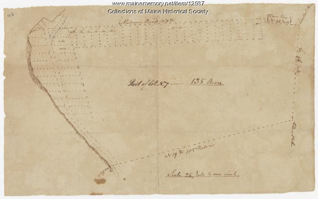
Map of lot no. 7, 135 acres on Madison Road, Skowhegan, ca. 1760
Contributed by: Maine Historical Society Date: circa 1760 Location: Skowhegan Media: Ink on paper
Item 16711

The Marble Works, Sanford, ca. 1900
Contributed by: Sanford-Springvale Historical Society Date: circa 1900 Location: Sanford Media: Print from Glass Negative
Item 102673

Contributed by: Bridgton Historical Society Date: circa 1938 Location: Bridgton Media: Ink on paper, photograph
Item 112087

Pejepscot Company Records, Volume 4, 1627-1866
Contributed by: Maine Historical Society Date: 1627–1866 Location: Brunswick Media: Ink on paper
Item 31696

Kennebec Proprietors map, Hallowell, April 1771
Contributed by: Hubbard Free Library Date: 1761-06-17 Location: Hallowell Media: Ink on paper
Item 58324

Mount Vernon land controversy, ca. 1806
Contributed by: Maine Historical Society Date: 1806 Location: Mount Vernon Media: Ink on paper
Item 108750

Contributed by: Maine Historical Society Date: 1834-10-02 Location: Leeds Media: Ink on paper
Item 12558

Contributed by: Maine Historical Society Date: circa 1800 Location: Skowhegan Media: Ink on paper
