LC Subject Heading: Maps, Early
- Historical Items (113)
- Tax Records (0)
- Architecture & Landscape (0)
- Online Exhibits (0)
- Site Pages (0)
- My Maine Stories (0)
- Lesson Plans (0)
Historical Items
These results include photographs, documents, letters, paintings, artifacts, and many other kinds of Maine related items from collections around the state and elsewhere.
Item 11718

Contributed by: Maine Historical Society Date: circa 1740 Location: Brunswick Media: Ink on paper
Item 11719
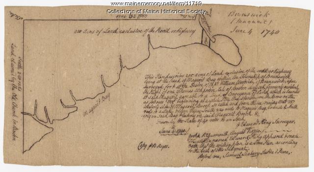
Contributed by: Maine Historical Society Date: 1740-06-04 Location: Brunswick Media: Ink on paper
Item 11720

Contributed by: Maine Historical Society Date: 1740-09-29 Location: Brunswick Media: Ink on paper
Item 11721

Plan of Land at Brunswick Narrows, 1741
Contributed by: Maine Historical Society Date: 1741 Location: Brunswick Media: Ink on paper
Item 11722

Map of Brunswick, lots on Merrymeeting Bay, ca. 1750
Contributed by: Maine Historical Society Date: circa 1750 Location: Brunswick Media: Ink on paper
Item 11723

Contributed by: Maine Historical Society Date: 1747-07-06 Location: Brunswick Media: Ink on paper
Item 11725

Contributed by: Maine Historical Society Date: 1772 Location: Brunswick Media: Ink on paper
Item 11728

Plan of a road in Brunswick, 1764
Contributed by: Maine Historical Society Date: 1764 Location: Brunswick; Bath Media: Ink on paper
Item 11758

Samuel and Hugh Wilson's lot in Topsham, 1758
Contributed by: Maine Historical Society Date: 1758 Location: Topsham; Brunswick Media: Ink on paper
Item 11922

Contributed by: Maine Historical Society Date: 1752-08-26 Location: Brunswick Media: Ink on paper
Item 11943

Contributed by: Maine Historical Society Date: 1749-12-04 Location: Brunswick Media: Ink on paper
Item 11975

Plan of Ruscohegon Alias Parker's Island, Georgetown, 1759
Contributed by: Maine Historical Society Date: 1759-03-22 Location: Georgetown Media: Ink on paper
Item 12200

Maps of lots on the Androscoggin River, ca. 1760
Contributed by: Maine Historical Society Date: circa 1760 Location: Jay; Canton; Livermore Falls Media: Ink on paper
Item 12400

Draper's claim northeast of Bath, 1795
Contributed by: Maine Historical Society Date: 1795 Media: Ink on paper
Item 12850

Tract of land belonging to Sylvester Gardiner, Bath, 1764
Contributed by: Maine Historical Society Date: 1764-12-08 Location: Georgetown; Bath Media: Ink on paper
Item 12853

Obadiah and Phillip Call's properties, Dresden, August 7, 1758
Contributed by: Maine Historical Society Date: 1758-08-07 Location: Dresden Media: Ink on paper
Item 12886

James Bowdoin's property, Lisbon, ca. 1770
Contributed by: Maine Historical Society Date: circa 1770 Location: Lewiston; Lisbon Media: Ink on paper
Item 13074

Manuscript map of Kennebec River area, 1771
Contributed by: Maine Historical Society Date: 1771 Media: Ink on paper
Item 68863

Copy of a plan of Black Point, Scarborough, 1741
Contributed by: Maine Historical Society Date: 1741 Location: Scarborough Media: Ink on paper, map
Item 4317

Cathance Mill lots, Topsham, 1759
Contributed by: Maine Historical Society Date: 1759-01-05 Location: Topsham Media: Ink on paper
Item 68864

James Libby land in Scarborough, 1773
Contributed by: Maine Historical Society Date: 1773 Location: Scarborough Media: Ink and wash on paper
Item 68872

Plan of farm, Scarborough, 1741
Contributed by: Maine Historical Society Date: 1741 Location: Cape Elizabeth Media: Ink on paper
Item 102068

"Tract of land lying in Poland," 1798
Contributed by: Maine Historical Society Date: 1798 Location: Auburn; Poland; Minot; Turner Media: Ink on paper
Item 116516

Extract from a Map of the British and French Dominions in North America, 1755
Contributed by: Maine Historical Society Date: circa 1755 Media: Ink on paper
