Keywords: Maine-Maps
- Historical Items (208)
- Tax Records (0)
- Architecture & Landscape (1)
- Online Exhibits (4)
- Site Pages (162)
- My Maine Stories (0)
- Lesson Plans (0)
Historical Items
These results include photographs, documents, letters, paintings, artifacts, and many other kinds of Maine related items from collections around the state and elsewhere.
Item 108766

Plan of lot no. 1, Lewiston, ca. 1800
Contributed by: Maine Historical Society Date: circa 1800 Location: Lewiston Media: Ink on paper
Item 108768

Survey of lot no. 90, Durham, ca. 1790
Contributed by: Maine Historical Society Date: circa 1790 Location: Durham Media: Ink on paper
Item 11743

Contributed by: Maine Historical Society Date: 1742-11-12 Location: Harpswell Media: Ink on paper
Item 105318

Map of the town of Camden, 1875
Contributed by: Osher Map Library and Smith Center for Cartographic Education Date: 1875 Location: Camden; Rockland Media: Lithograph
Item 105434

Map of the town of Thomaston, 1855
Contributed by: Osher Map Library and Smith Center for Cartographic Education Date: 1855 Location: Thomaston Media: Lithograph
Item 105436

Contributed by: Osher Map Library and Smith Center for Cartographic Education Date: 1856 Location: Gardiner Media: Lithograph
Item 4317

Cathance Mill lots, Topsham, 1759
Contributed by: Maine Historical Society
Date: 1759-01-05
Location: Topsham
Media: Ink on paper
This record contains 2 images.
Item 6846

Plan of Saint Croix River, Calais, 1807
Contributed by: Maine Historical Society Date: 1807 Location: Calais Media: Ink on paper
Item 7533

Map of Cape Elizabeth, Richmond Island area, 1884
Contributed by: Maine Historical Society Date: circa 1630 Location: Cape Elizabeth; Richmond Island Media: Ink on paper
Item 18722

Modern rendering of John Small's map of Falmouth, 1753
Contributed by: Maine Historical Society Date: 1753 Location: Falmouth Media: Map, ink on paper
Item 59801

Freeport electric railroads map, ca. 1929
Contributed by: Seashore Trolley Museum Date: circa 1929 Location: Freeport Media: Ink on paper
Item 59807

Gardiner to Augusta to Winthrop electric railroads, ca. 1932
Contributed by: Seashore Trolley Museum Date: circa 1932 Location: Augusta; Winthrop; Gardiner; Manchester Media: Ink on paper
Item 59811

Skowhegan, Norridgewock, & Madison electric railway lines, ca. 1928
Contributed by: Seashore Trolley Museum Date: circa 1928 Location: Norridgewock; Skowhegan Media: Ink on paper
Item 59812

Rockland, Thomaston & Camden electric railroad lines, ca. 1931
Contributed by: Seashore Trolley Museum Date: circa 1931 Location: Rockport; Rockland; Thomaston; Owls Head; Camden Media: Ink on paper
Item 98903
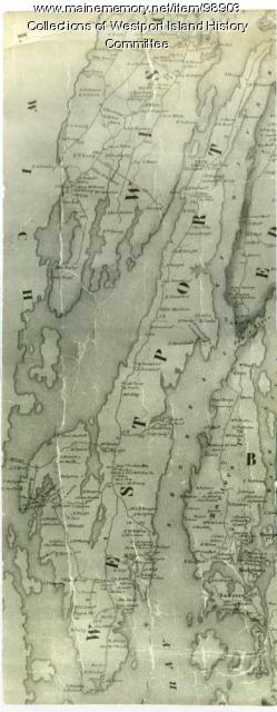
Contributed by: Westport Island History Committee Date: 1857 Location: Westport Island Media: Ink on paper, photograph
Item 100725

Contributed by: Maine Historical Society Date: 1858 Location: Portland Media: Lithograph with hand-coloring
Item 104602

A plan of the District of Maine, 1795
Contributed by: Osher Map Library and Smith Center for Cartographic Education Date: 1795 Media: Ink on Paper
Item 116516

Extract from a Map of the British and French Dominions in North America, 1755
Contributed by: Maine Historical Society
Date: circa 1755
Media: Ink on paper
This record contains 2 images.
Item 148262

Contributed by: Maine Historical Society Date: circa 1804 Location: Portland; Cape Elizabeth; Westbrook; Gorham; Scarborough Media: ink on paper
Item 148717

Map of the southern half of T3 R13, 1909
Contributed by: Maine Historical Society Date: 1909 Location: T3 R13 WELS Media: Ink on paper
Item 148738

Proposed Windy Ledges holding ground, Fort Kent, 1928
Contributed by: Maine Historical Society Date: 1928 Location: Fort Kent; St. John; St. Francis Parish Media: Ink on linen; hand coloring; graphite on linen
Item 148741

Map of part of Township 1, Range 9, 1919
Contributed by: Maine Historical Society Date: 1919–1930 Location: T1 R9 WELS Media: Ink on linen
Item 148742

Timber map of the west half of T9 R3, 1938
Contributed by: Maine Historical Society Date: 1938 Location: T9 R3 WELS Media: Ink on linen; hand coloring
Item 5335

Brunswick and Topsham, ca. 1730
Contributed by: Maine Historical Society Date: circa 1730 Location: Brunswick; Topsham Media: Ink on paper
