Keywords: Survey Map
- Historical Items (193)
- Tax Records (0)
- Architecture & Landscape (79)
- Online Exhibits (12)
- Site Pages (65)
- My Maine Stories (0)
- Lesson Plans (0)
Historical Items
These results include photographs, documents, letters, paintings, artifacts, and many other kinds of Maine related items from collections around the state and elsewhere.
Item 116538
St. John River boundary survey, No. 1, 1844
Contributed by: Maine Historical Society Date: 1844 Media: Ink on paper
Item 11779
Plan of a section of Portland called The Oaks, ca. 1845
Contributed by: Maine Historical Society Date: circa 1845 Location: Portland Media: Ink on paper, map
Item 116555
St. John River Boundary survey, 1843-1844
Contributed by: Maine Historical Society
Date: 1843–1844
Media: Ink on paper
This record contains 6 images.
Item 108760
Survey of lots near Great and Little Androscoggin Rivers, ca. 1800
Contributed by: Maine Historical Society Date: circa 1800 Media: Ink on paper
Item 116498
Manuscript survey of Lac La Croci, Vermillion Lake, ca. 1820
Contributed by: Maine Historical Society
Date: circa 1820
Media: Ink on paper
This record contains 2 images.
Item 148978
Map of Township 3 Range 9, ca. 1915
Contributed by: Maine Historical Society Date: circa 1915 Location: T3 R9 WELS Media: Ink on linen; hand coloring
Item 102252
Plan of burial ground, Minot, ca. 1835
Contributed by: Maine Historical Society
Date: 1835
Location: Minot
Media: Ink on paper
This record contains 3 images.
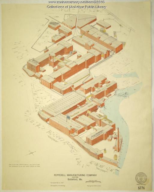
Item 28910
Pepperell Manufacturing fire insurance map, 1929
Contributed by: McArthur Public Library Date: 1929-10-10 Location: Biddeford Media: Ink on paper
Item 116510
Survey of Lake Huron, West Main Shore, ca. 1820
Contributed by: Maine Historical Society
Date: circa 1820
Media: Ink on paper
This record contains 2 images.
Item 108758
Survey of part of lot 155, 1841
Contributed by: Maine Historical Society Date: 1841-06-17 Media: Ink on paper
Item 108757
Survey of land eastern side of No Name Pond, Lewiston, ca. 1800
Contributed by: Maine Historical Society
Date: circa 1800
Location: Lewiston
Media: Ink on paper
This record contains 2 images.
Item 11657
Map of the Mouth of the St. Francis River, 1843
Contributed by: Maine Historical Society Date: 1843 Media: Ink on paper
Item 9600
Cocumgomucsis Lake view to Katahdin, Talcott Survey, 1841
Contributed by: Maine Historical Society Date: 1840 Media: Phototransparency
Item 9259
Early map of the Salmon Falls River in Lebanon, 1766
Contributed by: Maine Historical Society Date: 1766 Location: Lebanon Media: Ink on paper
Item 135996
John Mitchell Deposition, Map & Field Book, 1764
Contributed by: Maine Historical Society
Date: 1764
Location: St. Andrews
Media: Ink on Paper
This record contains 56 images.
Item 108853
A plan of a survey of sundry settlers' lots in Sheepscut Great Pond Settlement, 1802
Contributed by: Maine Historical Society
Date: circa 1802
Location: Palermo
Media: ink on paper
This record contains 2 images.
Item 111049
Survey of Muddy Lake, ca. 1822
Contributed by: Maine Historical Society
Date: circa 1822
Media: Ink on paper
This record contains 20 images.
Item 148741
Map of part of Township 1, Range 9, 1919
Contributed by: Maine Historical Society Date: 1919–1930 Location: T1 R9 WELS Media: Ink on linen
Item 6036
Contributed by: Maine Historical Society Date: circa 1800 Media: Ebony, ivory, brass
Item 11729
Land surveyed for Hugh Wilson, Topsham, 1761
Contributed by: Maine Historical Society Date: 1761-01-01 Location: Topsham Media: Ink on paper
Item 102068
"Tract of land lying in Poland," 1798
Contributed by: Maine Historical Society Date: 1798 Location: Auburn; Poland; Minot; Turner Media: Ink on paper
Item 12934
Land granted to William and Charles Cushing, Hallowell, 1771
Contributed by: Maine Historical Society
Date: 1771-10-03
Location: Hallowell; Augusta
Media: Ink on paper
This record contains 2 images.
Item 116525
Lake Huron, East Main Shore, ca. 1820
Contributed by: Maine Historical Society
Date: circa 1820
Media: Ink on paper
This record contains 2 images.
Item 148740
Township 5, Range 13 map, 1918
Contributed by: Maine Historical Society Date: 1918–1919 Location: T5 R13 WELS Media: Ink on linen


