Keywords: town maps
- Historical Items (337)
- Tax Records (0)
- Architecture & Landscape (25)
- Online Exhibits (25)
- Site Pages (168)
- My Maine Stories (3)
- Lesson Plans (0)
Historical Items
These results include photographs, documents, letters, paintings, artifacts, and many other kinds of Maine related items from collections around the state and elsewhere.
Item 10762

Enclosure map, Stroudwater, 1756
Contributed by: Maine Historical Society Date: 1756 Location: Portland; Westbrook Media: Ink on paper
Item 34148

Black Point, Scarborough, ca. 1741
Contributed by: Scarborough Historical Society & Museum Date: circa 1741 Location: Scarborough Media: Paper on cardboard
Item 102071

Map of early Greene, Lewiston and Sabattus, ca. 1790
Contributed by: Maine Historical Society Date: circa 1790 Location: Sabattus; Greene Media: Ink on vellum
Item 71155

Contributed by: Boston Public Library Date: 1888 Location: Bridgton Media: Ink on paper, lithograph
Item 105271

Birds eye view of Casco Bay, Portland, Maine and surroundings, 1906
Contributed by: Osher Map Library and Smith Center for Cartographic Education Date: 1906 Location: Portland Media: Lithograph
Item 5335

Brunswick and Topsham, ca. 1730
Contributed by: Maine Historical Society Date: circa 1730 Location: Brunswick; Topsham Media: Ink on paper
Item 12395

Map of Wesserunsett stream, 1790
Contributed by: Maine Historical Society
Date: 1790-12-12
Location: Canaan
Media: Ink on paper
This record contains 2 images.
Item 10545

Map of Ancient Falmouth from 1630 to 1690
Contributed by: Maine Historical Society Date: circa 1630 Location: Portland Media: Ink on paper
Item 71154

Bird's-eye view of Boothbay Harbor, 1885
Contributed by: Boston Public Library Date: 1885 Location: Boothbay Harbor Media: Ink on paper, lithograph
Item 71169

Bird's-eye view of Springvale, 1888
Contributed by: Boston Public Library Date: 1888 Location: Sanford Media: Ink on paper
Item 35631

Map of the city of Portsmouth, New Hampshire, 1850
Contributed by: Maine Historical Society Date: 1850 Location: Portsmouth; Kittery Media: Ink on paper
Item 100213

Plan of Longfellow and Preble lots, Portland, 1838
Contributed by: Maine Historical Society Date: 1838 Location: Portland Media: Pencil on paper
Item 11722

Map of Brunswick, lots on Merrymeeting Bay, ca. 1750
Contributed by: Maine Historical Society
Date: circa 1750
Location: Brunswick
Media: Ink on paper
This record contains 2 images.
Item 58323
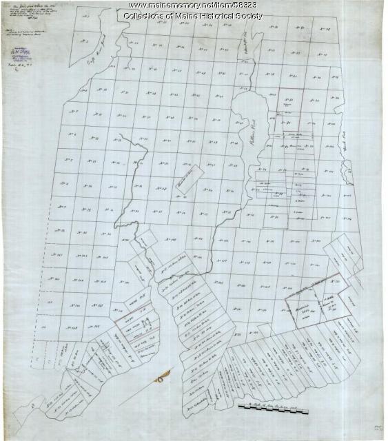
Copy of Surry and Ellsworth map, ca. 1880
Contributed by: Maine Historical Society Date: circa 1880 Location: Ellsworth; Surry Media: Ink on paper
Item 11730

Contributed by: Maine Historical Society Date: 1761-11-12 Location: Topsham Media: Ink on paper
Item 22699

Contributed by: Maine Historical Society Date: circa 1875 Location: Portland Media: Lantern slide
Item 108858

Plan of 200 acres on the Western Side of Kennebec River, Frankfort Plantation, 1758
Contributed by: Maine Historical Society
Date: 1758
Location: Dresden
Media: Ink on paper
This record contains 2 images.
Item 11725

Contributed by: Maine Historical Society Date: 1772 Location: Brunswick Media: Ink on paper
Item 102072

Plan of Royalsborough, ca. 1766
Contributed by: Maine Historical Society Date: circa 1766 Location: Durham Media: Ink on vellum
Item 11717

Contributed by: Maine Historical Society Date: circa 1718 Location: Brunswick; Harpswell; Bath; Topsham Media: Ink on paper
Item 31520

Locating the old houses of Cumberland map, by Hope Dilloway, 1989
Contributed by: Prince Memorial Library Date: circa 1871 Location: Cumberland Media: Ink and watercolor on paper
Item 22214
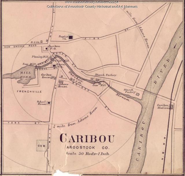
Contributed by: Aroostook County Historical and Art Museum Date: circa 1870 Location: Caribou Media: Ink on paper
Item 12411

Samuel and Hugh Wilson survey, 1767
Contributed by: Maine Historical Society Date: 1767 Location: Brunswick Media: Ink on paper
Item 11966

Filling Back Cove, Portland, 1837-2003
Contributed by: City of Portland Dept. of Public Works Date: 1837 Location: Portland Media: Ink on paper, map
