Keywords: Survey Map
- Historical Items (194)
- Tax Records (0)
- Architecture & Landscape (79)
- Online Exhibits (12)
- Site Pages (103)
- My Maine Stories (0)
- Lesson Plans (0)
Historical Items
These results include photographs, documents, letters, paintings, artifacts, and many other kinds of Maine related items from collections around the state and elsewhere.
Item 148740

Township 5, Range 13 map, 1918
Contributed by: Maine Historical Society Date: 1918–1919 Location: T5 R13 WELS Media: Ink on linen
Item 12571

Contributed by: Maine Historical Society
Date: 1810-06-15
Location: Windsor
Media: Ink on paper
This record contains 4 images.
Item 10537

Contributed by: Maine Historical Society Date: 1717 Location: Brunswick Media: Ink on paper
Item 116514

St. John River boundary survey, Little Black River rapids, ca. 1843
Contributed by: Maine Historical Society Date: circa 1843 Media: Ink on paper
Item 116509

Survey of the South Main Shore of Lake Huron, ca. 1820
Contributed by: Maine Historical Society Date: circa 1820 Media: Ink on paper
Item 11715
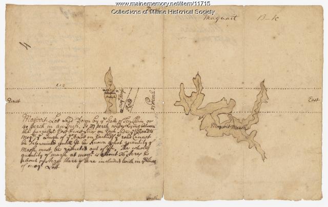
Plan of Maquoit Meadows, ca. 1720
Contributed by: Maine Historical Society Date: circa 1720 Location: Brunswick Media: Ink on paper
Item 108752

Plan of William Libby's lot, Durham, 1819
Contributed by: Maine Historical Society Date: 1819-12-08 Location: Durham Media: Ink on paper
Item 108751

50 acres bargained, Leeds, 1834
Contributed by: Maine Historical Society
Date: 1834-10-02
Location: Leeds
Media: Ink on paper
This record contains 3 images.
Item 12382

Plan of Kennebeck River, ca. 1765
Contributed by: Maine Historical Society
Date: circa 1765
Media: Ink on paper
This record contains 2 images.
Item 68873

Zebulon Libbey's land, Scarborough, 1769
Contributed by: Maine Historical Society Date: 1769 Location: Scarborough Media: Ink and wash on paper
Item 11972

Contributed by: Maine Historical Society Date: circa 1740 Location: Harpswell Media: Ink on paper
Item 11721

Plan of Land at Brunswick Narrows, 1741
Contributed by: Maine Historical Society Date: 1741 Location: Brunswick Media: Ink on paper
Item 108754

Plan excepting a road to Durham, 1821
Contributed by: Maine Historical Society Date: 1821-06-29 Location: Durham Media: Ink on paper
Item 12938

Ten lots near Sebasticook River, ca. 1760
Contributed by: Maine Historical Society
Date: circa 1760
Location: China; Vassalboro
Media: Ink on paper
This record contains 2 images.
Item 108755

Land of Samuel Sylvester, Prout's Gore, 1813
Contributed by: Maine Historical Society Date: 1813-11-05 Location: Freeport Media: Ink on paper
Item 108831

Contributed by: Maine Historical Society
Date: 1774-03-29
Location: Vassalboro
Media: Ink on paper
This record contains 2 images.
Item 11454

Contributed by: Maine Historical Society Date: 1763-08-11 Location: Brunswick; Topsham Media: Ink on paper
Item 27752

Plan of the Androscoggin River at Brunswick & Topsham, 1835
Contributed by: Maine Historical Society Date: 1835 Location: Topsham; Brunswick Media: Ink on paper
Item 110976

Manuscript survey of Indian Stream, New Hampshire, 1843-1844
Contributed by: Maine Historical Society
Date: 1843–1844
Location: Pittsburg
Media: Ink on paper
This record contains 5 images.
Item 11748

Joshua Scottow's land boundary, Brunswick, 1737
Contributed by: Maine Historical Society Date: 1737-06-24 Location: Brunswick Media: Ink on paper
Item 22490

Contributed by: Maine Historical Society Date: 1851 Location: Cape Elizabeth Media: Ink on paper, map
Item 20763

Penobscot River and Chesuncook Lake, 1820
Contributed by: Maine Historical Society Date: 1820 Media: Ink on paper
Item 68864

James Libby land in Scarborough, 1773
Contributed by: Maine Historical Society Date: 1773 Location: Scarborough Media: Ink and wash on paper
Item 37702

Contributed by: Maine Historical Society Date: 1764-09-15 Media: Ink on paper
