Keywords: Land survey
- Historical Items (121)
- Tax Records (0)
- Architecture & Landscape (127)
- Online Exhibits (22)
- Site Pages (76)
- My Maine Stories (2)
- Lesson Plans (0)
Historical Items
These results include photographs, documents, letters, paintings, artifacts, and many other kinds of Maine related items from collections around the state and elsewhere.
Item 108768

Survey of lot no. 90, Durham, ca. 1790
Contributed by: Maine Historical Society Date: circa 1790 Location: Durham Media: Ink on paper
Item 108756

Plot adjacent to Peables' fence, ca. 1800
Contributed by: Maine Historical Society Date: circa 1800 Media: Ink on paper
Item 108753

Plan of the Bracket Lots, Androscoggin County, ca. 1800
Contributed by: Maine Historical Society
Date: circa 1800
Location: Durham
Media: Ink on paper
This record contains 2 images.
Item 108765

Edward Little plan of lots, ca. 1820
Contributed by: Maine Historical Society Date: circa 1820 Media: Ink on paper
Item 108750

Contributed by: Maine Historical Society
Date: 1834-10-02
Location: Leeds
Media: Ink on paper
This record contains 3 images.
Item 108759

Survey of land in Poland, 1842
Contributed by: Maine Historical Society Date: 1842 Location: Poland Media: Ink on paper
Item 108764

Plan of suit, Little v. Field, 1823
Contributed by: Maine Historical Society Date: 1823 Media: Ink on paper
Item 102068

"Tract of land lying in Poland," 1798
Contributed by: Maine Historical Society Date: 1798 Location: Auburn; Poland; Minot; Turner Media: Ink on paper
Item 108767

Plan of land in Brunswick, ca. 1800
Contributed by: Maine Historical Society Date: circa 1800 Location: Brunswick Media: Ink on paper
Item 108766

Plan of lot no. 1, Lewiston, ca. 1800
Contributed by: Maine Historical Society Date: circa 1800 Location: Lewiston Media: Ink on paper
Item 108755

Land of Samuel Sylvester, Prout's Gore, 1813
Contributed by: Maine Historical Society Date: 1813-11-05 Location: Freeport Media: Ink on paper
Item 116533

St. John River boundary survey, 1843-1844
Contributed by: Maine Historical Society Date: circa 1844 Media: Ink on paper
Item 108757

Survey of land eastern side of No Name Pond, Lewiston, ca. 1800
Contributed by: Maine Historical Society
Date: circa 1800
Location: Lewiston
Media: Ink on paper
This record contains 2 images.
Item 11729

Land surveyed for Hugh Wilson, Topsham, 1761
Contributed by: Maine Historical Society Date: 1761-01-01 Location: Topsham Media: Ink on paper
Item 102070

Early map of Lewiston, Auburn and Minot, ca. 1820
Contributed by: Maine Historical Society Date: circa 1820 Location: Auburn; Lewiston; Minot Media: Ink on paper
Item 11748

Joshua Scottow's land boundary, Brunswick, 1737
Contributed by: Maine Historical Society Date: 1737-06-24 Location: Brunswick Media: Ink on paper
Item 28353
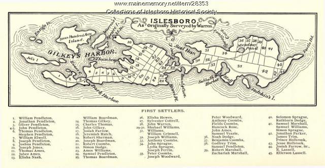
Warren Survey Map, Islesboro, ca. 1893
Contributed by: Islesboro Historical Society Date: circa 1799 Location: Islesboro Media: Ink on paper
Item 11721

Plan of Land at Brunswick Narrows, 1741
Contributed by: Maine Historical Society Date: 1741 Location: Brunswick Media: Ink on paper
Item 116534

St. John River boundary survey, Five Islands, 1843
Contributed by: Maine Historical Society Date: 1843 Media: Ink on paper
Item 116515

St. John River boundary survey, from Rose Island north and east, 1844
Contributed by: Maine Historical Society Date: 1844 Media: Ink on paper
Item 109022

Disputed lot E, Brunswick, 1811
Contributed by: Maine Historical Society
Date: 1811-09-03
Location: Brunswick
Media: Ink on paper
This record contains 3 images.
Item 116537

St. John River boundary survey no. 2, 1843
Contributed by: Maine Historical Society Date: 1843 Media: Ink on paper
Item 102252

Plan of burial ground, Minot, ca. 1835
Contributed by: Maine Historical Society
Date: 1835
Location: Minot
Media: Ink on paper
This record contains 3 images.
Item 12934

Land granted to William and Charles Cushing, Hallowell, 1771
Contributed by: Maine Historical Society
Date: 1771-10-03
Location: Hallowell; Augusta
Media: Ink on paper
This record contains 2 images.
