Keywords: New England -- Maps -- Early works to 1800
- Historical Items (18)
- Tax Records (0)
- Architecture & Landscape (0)
- Online Exhibits (4)
- Site Pages (22)
- My Maine Stories (0)
- Lesson Plans (0)
Historical Items
These results include photographs, documents, letters, paintings, artifacts, and many other kinds of Maine related items from collections around the state and elsewhere.
Item 104938

"New England the Most Remarqueable Parts Thus Named," 1637
Contributed by: Osher Map Library and Smith Center for Cartographic Education Date: circa 1614 Media: Engraving
Item 7492

Novi Belgii: Novaeque Angliae Nec Non partis Virginiae, ca. 1655
Contributed by: Maine Historical Society Date: circa 1655 Media: Map, ink on paper
Item 104604

New Map of English America, 1677
Contributed by: Osher Map Library and Smith Center for Cartographic Education Date: 1777 Media: Engraving
Item 7493

Nova Anglia Septentrionali, ca. 1759
Contributed by: Maine Historical Society Date: circa 1720 Media: Map ink on paper
Item 7489

Nova Anglia, Novum Belgium et Virginia, ca. 1642
Contributed by: Maine Historical Society Date: circa 1642 Media: Map, ink on paper
Item 7494

Map of New England and New York, ca. 1676
Contributed by: Maine Historical Society Date: circa 1676 Media: Ink on paper
Item 104601

Contributed by: Osher Map Library and Smith Center for Cartographic Education Date: 1677 Media: Woodcut
Item 7490

Nova Belgica et Anglia Nova, ca. 1635
Contributed by: Maine Historical Society Date: circa 1635 Media: Map, ink on paper
Item 4325

"Brunswick in the late Province of Mayne in New England," 1719
Contributed by: Maine Historical Society
Date: 1718-01-28
Location: Brunswick
Media: Ink on paper
This record contains 2 images.
Item 135882

Contributed by: Osher Map Library and Smith Center for Cartographic Education Date: 1761 Media: Ink on paper
Item 7541

Reproduction of 1620 Charter from King James I to the Council for New England, 1885
Contributed by: Maine Historical Society Date: 1620-11-03 Media: Ink on paper
Item 7540

Map of the New England Coast, 1610
Contributed by: Maine Historical Society Date: 1610 Media: Ink on paper
Item 6665

Pascatway River in New England, ca. 1890
Contributed by: Maine State Archives Date: circa 1670 Media: Paper
Item 11945

Ramusio's Delle Nava Gationi, 1565
Contributed by: Maine Historical Society Date: 1565 Media: Ink on paper
Item 105015

Figure de la Terre Neuve, grande riviere de Canada, et cotes de l'ocean en la Nouvelle France, 1618
Contributed by: Maine Historical Society Date: 1607 Media: Ink on paper
Item 10763
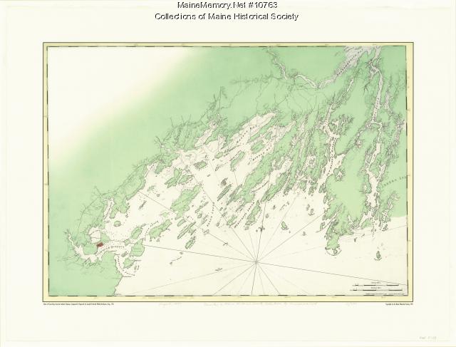
Chart of Casco Bay from the Atlantic Neptune, 1776
Contributed by: Maine Historical Society Date: circa 1776 Media: Ink on paper, map
Item 12126

Kennebec and Sagadahoc Rivers, 1755
Contributed by: Maine Historical Society
Date: 1754
Media: Ink on paper
This record contains 2 images.
Item 11929
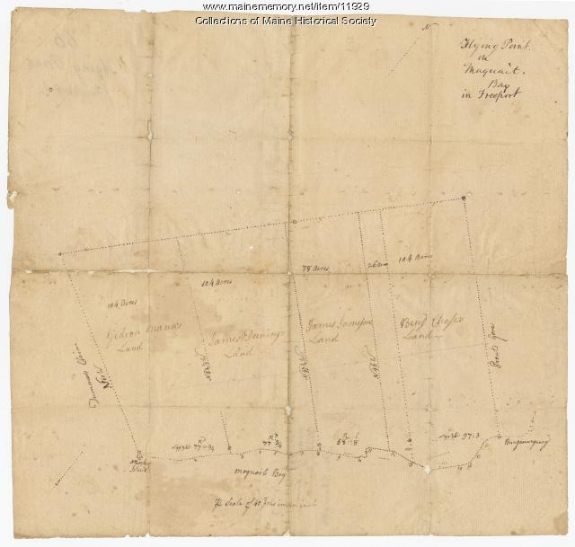
Flying Point at Maquoit Bay, Freeport, ca. 1770
Contributed by: Maine Historical Society Date: circa 1770 Location: Freeport; Brunswick Media: Ink on paper
