Keywords: Street map
- Historical Items (89)
- Tax Records (0)
- Architecture & Landscape (46)
- Online Exhibits (19)
- Site Pages (60)
- My Maine Stories (2)
- Lesson Plans (0)
Historical Items
These results include photographs, documents, letters, paintings, artifacts, and many other kinds of Maine related items from collections around the state and elsewhere.
Item 105436

Contributed by: Osher Map Library and Smith Center for Cartographic Education Date: 1856 Location: Gardiner Media: Lithograph
Item 105437

Contributed by: Osher Map Library and Smith Center for Cartographic Education Date: 1856 Location: Maine Media: Lithograph
Item 100727

Contributed by: Maine Historical Society Date: 1826 Location: Portland Media: Watercolor and pen and ink, mounted on fabric
Item 35628

Map of 1866 Portland Fire, 1866
Contributed by: Maine Historical Society Date: 1866-07-04 Location: Portland Media: Ink on paper
Item 105266

Contributed by: Osher Map Library and Smith Center for Cartographic Education Date: 1859 Location: Maine Media: Lithograph
Item 100725

Contributed by: Maine Historical Society Date: 1858 Location: Portland Media: Lithograph with hand-coloring
Item 11043

Waterfront and downtown Bath, 1851
Contributed by: Patten Free Library Date: 1851 Location: Bath Media: Ink on paper
Item 11965

Contributed by: City of Portland Dept. of Public Works Date: 1773 Location: Portland Media: Ink on paper, map
Item 16011

64-66 School Street, Sanford, ca. 1910
Contributed by: Sanford-Springvale Historical Society Date: circa 1910 Location: Sanford Media: Print from Glass Negative
Item 10887

Map from Hay's Guide to Portland and Motoring in Maine, 1928
Contributed by: Maine Historical Society Date: 1928 Location: Maine Media: Ink on paper, map
Item 9948

12 Bodwell Street, Broggi Home, Sanford, ca. 1900
Contributed by: Sanford-Springvale Historical Society Date: circa 1900 Location: Sanford Media: Photographic print
Item 9949

12 Bodwell Street, Broggi Home, Sanford, ca. 1900
Contributed by: Sanford-Springvale Historical Society Date: circa 1900 Location: Sanford Media: Photographic print
Item 100726

Plan of Portland enhanced with school districts, ca. 1858
Contributed by: Maine Historical Society Date: circa 1858 Location: Portland Media: Lithograph with hand coloring
Item 10890

Contributed by: Maine Historical Society Date: 1909 Location: Portland Media: Ink on paper
Item 11963
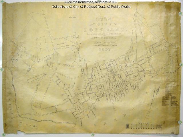
Plan of the City of Portland, 1837
Contributed by: City of Portland Dept. of Public Works Date: 1837 Location: Portland Media: Ink on paper, map
Item 11989

Plan of Ann (now Park) Street, Portland, ca. 1802
Contributed by: Maine Historical Society Date: circa 1802 Location: Portland Media: Pen, Ink and watercolor on paper, map
Item 22212

Contributed by: Aroostook County Historical and Art Museum Date: circa 1870 Location: Houlton Media: Ink on paper
Item 28545

Bird's-eye view detail, Bath, 1878
Contributed by: Patten Free Library Date: 1878 Location: Bath Media: Ink on paper
Item 74738

Contributed by: Maine Historical Society Date: 1927 Location: Maine Media: Ink on paper
Item 28910
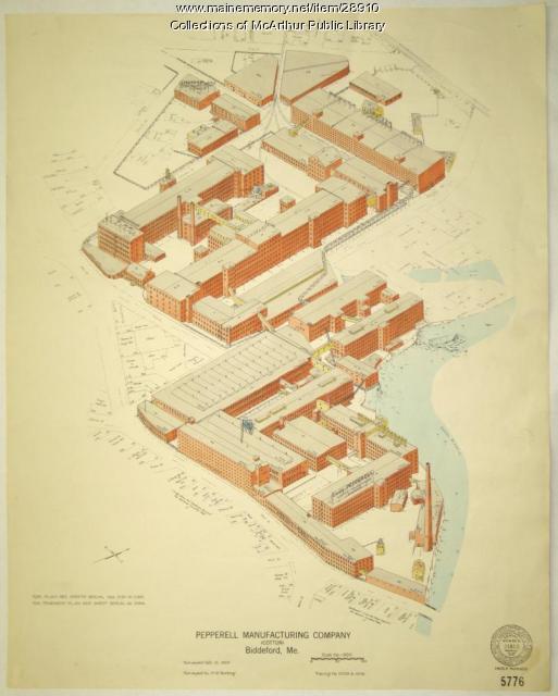
Pepperell Manufacturing fire insurance map, 1929
Contributed by: McArthur Public Library Date: 1929-10-10 Location: Biddeford Media: Ink on paper
Item 59801

Freeport electric railroads map, ca. 1929
Contributed by: Seashore Trolley Museum Date: circa 1929 Location: Freeport Media: Ink on paper
Item 11962

Contributed by: City of Portland Dept. of Public Works Date: circa 1813 Location: Portland Media: Ink on paper, map
Item 52214

Map of Pepperell Park, Saco, 1884
Contributed by: Dyer Library/Saco Museum Date: 1884 Location: Saco Media: Photographic print
Item 11960

Plan of land on Bramhall Hill by Peleg Wadsworth, ca. 1800
Contributed by: City of Portland Dept. of Public Works Date: circa 1800 Location: Portland Media: Ink and wash on paper, map
