LC Subject Heading: Maps, Manuscript
- Historical Items (227)
- Tax Records (0)
- Architecture & Landscape (0)
- Online Exhibits (0)
- Site Pages (0)
- My Maine Stories (0)
- Lesson Plans (0)
Historical Items
These results include photographs, documents, letters, paintings, artifacts, and many other kinds of Maine related items from collections around the state and elsewhere.
Item 35622

Contributed by: Maine Historical Society Date: 1871 Location: Lovell Media: Ink on paper
Item 9261

Contributed by: Maine Historical Society Date: 1814 Media: Pencil and ink
Item 25025

Luke Lambard to U.S. Marshall Thornton about 1820 census, Bath, 1820
Contributed by: Maine Historical Society Date: 1820 Location: Georgetown; Woolwich; Dresden Media: Ink on paper
Item 100727

Contributed by: Maine Historical Society Date: 1826 Location: Portland Media: Watercolor and pen and ink, mounted on fabric
Item 148262

Contributed by: Maine Historical Society Date: circa 1804 Location: Portland; Cape Elizabeth; Westbrook; Gorham; Scarborough Media: ink on paper
Item 20763

Penobscot River and Chesuncook Lake, 1820
Contributed by: Maine Historical Society Date: 1820 Media: Ink on paper
Item 11962

Contributed by: City of Portland Dept. of Public Works Date: circa 1813 Location: Portland Media: Ink on paper, map
Item 110913

"Part of Bug Island" map fragment, ca. 1823
Contributed by: Maine Historical Society
Date: circa 1823
Media: Ink on paper
This record contains 2 images.
Item 12133

Plan of that part of the county of Hancock lying on the Piscataquis.., 1806
Contributed by: Maine Historical Society Date: 1806 Media: Ink on parchment, map
Item 11779

Plan of a section of Portland called The Oaks, ca. 1845
Contributed by: Maine Historical Society Date: circa 1845 Location: Portland Media: Ink on paper, map
Item 59765
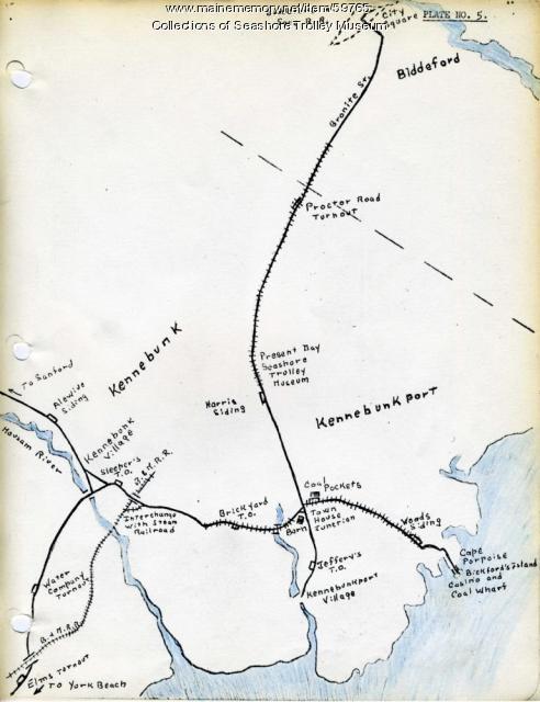
Kennebunk Village to Cape Porpoise electric railroads, ca. 1927
Contributed by: Seashore Trolley Museum Date: circa 1927 Location: Kennebunk; Cape Porpoise Media: Ink on paper
Item 110907

Contributed by: Maine Historical Society
Date: circa 1812
Location: Waterville
Media: Ink on paper
This record contains 2 images.
Item 11830

Map of the country explored, Maine and New Brunswick, ca. 1818
Contributed by: Maine Historical Society
Date: 1817
Media: Ink on paper
This record contains 7 images.
Item 4316

Plan of J. Robinson lot, Topsham, 1761
Contributed by: Maine Historical Society Date: 1761 Location: Topsham Media: Ink on paper
Item 6885

Plan of James Deering's Farm, Portland, 1843
Contributed by: Maine Historical Society Date: 1843 Location: Portland Media: Ink on paper
Item 20766

Manuscript Map of Moose River, Moosehead Lake, and Kennebeck Road, 1820
Contributed by: Maine Historical Society Date: 1820 Media: Ink on paper
Item 8564

North shore, Lake Huron, ca. 1819
Contributed by: Maine Historical Society
Date: circa 1819
Media: Ink on paper
This record contains 3 images.
Item 108853

A plan of a survey of sundry settlers' lots in Sheepscut Great Pond Settlement, 1802
Contributed by: Maine Historical Society
Date: circa 1802
Location: Palermo
Media: ink on paper
This record contains 2 images.
Item 110898

St. Regis Village at the river St. Lawrence, New York, ca. 1815
Contributed by: Maine Historical Society
Date: circa 1815
Location: Waverly
Media: Ink on paper
This record contains 2 images.
Item 116491

Manuscript map of Lake Superior to Lake of the Woods, ca. 1822
Contributed by: Maine Historical Society
Date: circa 1820
Media: Ink on paper
This record contains 2 images.
Item 116493

Crooked Lake and Lake Namacan, ca. 1820
Contributed by: Maine Historical Society
Date: circa 1820
Media: Ink on paper
This record contains 2 images.
Item 116495

Manuscript map of Loon's Narrows & Lac Du Bois, ca. 1822
Contributed by: Maine Historical Society
Date: circa 1822
Media: Ink on paper
This record contains 2 images.
Item 116498

Manuscript survey of Lac La Croci, Vermillion Lake, ca. 1820
Contributed by: Maine Historical Society
Date: circa 1820
Media: Ink on paper
This record contains 2 images.
Item 116547

Northeastern Boundary of Minnesota, ca. 1820
Contributed by: Maine Historical Society Date: circa 1820 Media: Ink on paper
