LC Subject Heading: Plymouth Company (1749-1816) -- Maps --
- Historical Items (23)
- Tax Records (0)
- Architecture & Landscape (0)
- Online Exhibits (0)
- Site Pages (0)
- My Maine Stories (0)
- Lesson Plans (0)
Historical Items
These results include photographs, documents, letters, paintings, artifacts, and many other kinds of Maine related items from collections around the state and elsewhere.
Item 31696

Kennebec Proprietors map, Hallowell, April 1771
Contributed by: Hubbard Free Library Date: 1761-06-17 Location: Hallowell Media: Ink on paper
Item 58324

Mount Vernon land controversy, ca. 1806
Contributed by: Maine Historical Society Date: 1806 Location: Mount Vernon Media: Ink on paper
Item 108835

Plan of lots 1-10, Fairfield, 1782
Contributed by: Maine Historical Society
Date: 1782-12-20
Location: Fairfield
Media: Ink on paper
This record contains 2 images.
Item 12196

Map of Kennebec Purchase lots, ca. 1750
Contributed by: Maine Historical Society
Date: circa 1750
Media: Ink on paper
This record contains 2 images.
Item 12939

Henry May, James Larking lot, near the Sheepscot River, 1805
Contributed by: Maine Historical Society
Date: 1805-11-25
Media: Ink on paper
This record contains 2 images.
Item 108833

Plan for Fort Western, Augusta, ca. 1750
Contributed by: Maine Historical Society
Date: circa 1750
Location: Augusta
Media: Ink on paper
This record contains 2 images.
Item 108853

A plan of a survey of sundry settlers' lots in Sheepscut Great Pond Settlement, 1802
Contributed by: Maine Historical Society
Date: circa 1802
Location: Palermo
Media: ink on paper
This record contains 2 images.
Item 12937
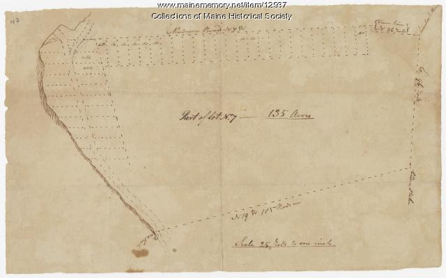
Map of lot no. 7, 135 acres on Madison Road, Skowhegan, ca. 1760
Contributed by: Maine Historical Society
Date: circa 1760
Location: Skowhegan
Media: Ink on paper
This record contains 2 images.
Item 12940

Map of lots G1 and G2 for James Pitts, near Clinton, 1769
Contributed by: Maine Historical Society
Date: 1769-11-07
Location: Skowhegan
Media: Ink on paper
This record contains 3 images.
Item 12944

Contributed by: Maine Historical Society
Date: 1764
Location: Sidney
Media: Ink on paper
This record contains 2 images.
Item 108837

Copy of Thomas Johnston's Plan of part of the Eastern Shore, ca. 1770
Contributed by: Maine Historical Society
Date: 1753
Media: Ink on paper
This record contains 2 images.
Item 108844

Plan of lots in Georgetown, 1759
Contributed by: Maine Historical Society
Date: 1759-03-14
Location: Bath
Media: Ink on paper
This record contains 2 images.
Item 108846

Contributed by: Maine Historical Society
Date: 1760-04-08
Location: West Bath
Media: Ink on paper
This record contains 2 images.
Item 108848

Map and petition, Sandy River, 1798
Contributed by: Maine Historical Society
Date: 1798
Location: New Vineyard; Farmington
Media: Ink on paper
This record contains 2 images.
Item 108862

Survey of lots for Peter Brown, Georgetown, 1761
Contributed by: Maine Historical Society Date: 1761-01-12 Location: Bath Media: Ink on paper
Item 122791

Plymouth Company Records, box 1/6, 1750–1751
Contributed by: Maine Historical Society
Date: 1750–1751
Location: Brunswick; Georgetown; Newcastle; Topsham; Wiscasset; Wiscassett; georgetown
Media: Ink on Paper
This record contains 48 images.
Item 12933

Wing's Mill Pond settlers' lots, ca. 1795
Contributed by: Maine Historical Society
Date: circa 1795
Location: Belgrade
Media: Ink on paper
This record contains 2 images.
Item 12934

Land granted to William and Charles Cushing, Hallowell, 1771
Contributed by: Maine Historical Society
Date: 1771-10-03
Location: Hallowell; Augusta
Media: Ink on paper
This record contains 2 images.
Item 12935

Purchases on the Kennebec River, 1731
Contributed by: Maine Historical Society
Date: 1629-01-30
Location: Richmond; Augusta
Media: Ink on paper
This record contains 2 images.
Item 12938

Ten lots near Sebasticook River, ca. 1760
Contributed by: Maine Historical Society
Date: circa 1760
Location: China; Vassalboro
Media: Ink on paper
This record contains 2 images.
Item 12943

Plan of lots on the Sheepscot River, Alna, 1798
Contributed by: Maine Historical Society
Date: 1759
Location: Alna
Media: Ink on paper
This record contains 2 images.
Item 37703

Kennebec and Sagadahok rivers plan, 1755
Contributed by: Maine Historical Society Date: circa 1755 Media: Ink on paper
Item 12941

Plan of the Kennebec River, Nov. 1763
Contributed by: Maine Historical Society
Date: 1763
Location: Richmond
Media: Ink on paper
This record contains 2 images.
