LC Subject Heading: Railroads--Maine--Maps
- Historical Items (17)
- Tax Records (0)
- Architecture & Landscape (0)
- Online Exhibits (0)
- Site Pages (0)
- My Maine Stories (0)
- Lesson Plans (0)
Historical Items
These results include photographs, documents, letters, paintings, artifacts, and many other kinds of Maine related items from collections around the state and elsewhere.
Item 105360

Contributed by: Osher Map Library and Smith Center for Cartographic Education Date: 1855 Media: Lithograph
Item 9539

Railroad map of northern New England and the Maritime Provinces, 1882
Contributed by: Maine Historical Society Date: 1882 Media: Ink on paper
Item 59765
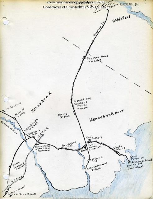
Kennebunk Village to Cape Porpoise electric railroads, ca. 1927
Contributed by: Seashore Trolley Museum Date: circa 1927 Location: Kennebunk; Cape Porpoise Media: Ink on paper
Item 105310

Birds eye view showing Portland Railroad System and connecting lines, 1909
Contributed by: Osher Map Library and Smith Center for Cartographic Education Date: 1909 Location: Saco; Portland; Portland; Old Orchard Beach; South Portland; Cape Elizabeth Media: Lithograph
Item 59770

Portland, South Portland, & Cape Elizabeth electric railroads, ca. 1941
Contributed by: Seashore Trolley Museum Date: circa 1941 Location: Portland Media: Ink on paper
Item 59772

Electric railroad route map, ca. 1933
Contributed by: Seashore Trolley Museum Date: circa 1933 Location: Portland; Falmouth; Yarmouth; Cumberland Media: Ink on paper
Item 59764

Kittery to York Beach electric railroad lines, ca. 1923
Contributed by: Seashore Trolley Museum Date: circa 1923 Location: York; Kittery Media: Ink on paper
Item 59802

Brunswick to Bath electric railroads, ca. 1937
Contributed by: Seashore Trolley Museum Date: circa 1937 Location: Bath; Brunswick Media: Ink on paper
Item 59804

Lewiston, Auburn, and Turner electric railroads, ca. 1928
Contributed by: Seashore Trolley Museum Date: circa 1928 Location: Lewiston; Auburn; Turner Media: Ink on paper
Item 59806

Sabattus Village to Dennis Hill electric railroads, ca. 1941
Contributed by: Seashore Trolley Museum Date: circa 1941 Location: Lewiston; Litchfield; Sabattus; Greene Media: Ink on paper
Item 11777

Contributed by: Maine Historical Society Date: circa 1905 Media: Ink on paper, map
Item 17574

Railroad map of Northern Maine, 1910
Contributed by: Maine Historical Society Date: 1910 Media: Ink on paper, map
Item 59801

Freeport electric railroads map, ca. 1929
Contributed by: Seashore Trolley Museum Date: circa 1929 Location: Freeport Media: Ink on paper
Item 59807

Gardiner to Augusta to Winthrop electric railroads, ca. 1932
Contributed by: Seashore Trolley Museum Date: circa 1932 Location: Augusta; Winthrop; Gardiner; Manchester Media: Ink on paper
Item 59811

Skowhegan, Norridgewock, & Madison electric railway lines, ca. 1928
Contributed by: Seashore Trolley Museum Date: circa 1928 Location: Norridgewock; Skowhegan Media: Ink on paper
Item 59812

Rockland, Thomaston & Camden electric railroad lines, ca. 1931
Contributed by: Seashore Trolley Museum Date: circa 1931 Location: Rockport; Rockland; Thomaston; Owls Head; Camden Media: Ink on paper
Item 16540

Map of the Rangeley Lake and Dead River regions, 1885
Contributed by: Maine Historical Society Date: 1885 Media: Ink on paper
