Keywords: River vessels
- Historical Items (59)
- Tax Records (0)
- Architecture & Landscape (0)
- Online Exhibits (28)
- Site Pages (35)
- My Maine Stories (2)
- Lesson Plans (0)
Online Exhibits
Your results include these online exhibits. You also can view all of the site's exhibits, view a timeline of selected events in Maine History, and learn how to create your own exhibit. See featured exhibits or create your own exhibit
Exhibit

Colonial Cartography: The Plymouth Company Maps
The Plymouth Company (1749-1816) managed one of the very early land grants in Maine along the Kennebec River. The maps from the Plymouth Company's collection of records constitute some of the earliest cartographic works of colonial America.
Exhibit

The Schooner Bowdoin: Ninety Years of Seagoing History
After traveling to the Arctic with Robert E. Peary, Donald B. MacMillan (1874-1970), an explorer, researcher, and lecturer, helped design his own vessel for Arctic exploration, the schooner <em>Bowdoin,</em> which he named after his alma mater. The schooner remains on the seas.
Exhibit

After the canoe, steamboats became the favored method of transportation on Moosehead Lake. They revolutionized movement of logs and helped promote tourism in the region.
Exhibit

George Popham and a group of fellow Englishmen arrived at the mouth of the Kennebec River, hoping to trade with Native Americans, find gold and other valuable minerals, and discover a Northwest passage. In 18 months, the fledgling colony was gone.
Exhibit

Washington County Through Eastern's Eye
Images taken by itinerant photographers for Eastern Illustrating and Publishing Company, a real photo postcard company, provide a unique look at industry, commerce, recreation, tourism, and the communities of Washington County in the early decades of the twentieth century.
Exhibit

A Town Is Born: South Bristol, 1915
After being part of the town of Bristol for nearly 150 years, residents of South Bristol determined that their interests would be better served by becoming a separate town and they broke away from the large community of Bristol.
Exhibit

From Sewers to Skylines: William S. Edwards's 1887 Photo Album
William S. Edwards (1830-1918) was a civil engineer who worked for the City of Portland from 1876-1906. Serving as First Assistant to Chief Engineer William A. Goodwin, then to Commissioner George N. Fernald, Edwards was a fixture in City Hall for 30 consecutive years, proving indispensable throughout the terms of 15 Mayors of Portland, including all six of those held by James Phineas Baxter. Edwards made significant contributions to Portland, was an outstanding mapmaker and planner, and his works continue to benefit historians.
Exhibit
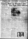
Rum, Riot, and Reform - Bootleggers vs. Police
"Smaller vessels would buy up liquor and try to return to shore undetected. Confiscated liquor bottles, Portland, 1927Maine Historical…"
Exhibit

Scientist, author and explorer Donald B. MacMillan established Wiscasset as his homeport for many of the voyages he made to the Arctic region starting in the early 1920s.
Exhibit

Sagadahoc County through the Eastern Eye
The Eastern Illustrating and Publishing Company of Belfast, Maine. employed photographers who traveled by company vehicle through New England each summer, taking pictures of towns and cities, vacation spots and tourist attractions, working waterfronts and local industries, and other subjects postcard recipients might enjoy. The cards were printed by the millions in Belfast into the 1940s.
Exhibit

Maine's first governor, William King, was arguably the most influential figure in Maine's achieving statehood in 1820. Although he served just one year as the Governor of Maine, he was instrumental in establishing the new state's constitution and setting up its governmental infrastructure.
Exhibit

Bowdoin College Scientific Expedition to Labrador
"The Bowdoin Boys" -- some students and recent graduates -- traveled to Labrador in 1891 to collect artifacts, specimens, and to try to find Grand Falls, a waterfall deep in Labrador's interior.
Exhibit

Liberty Threatened: Maine in 1775
At Lexington and Concord, on April 19, 1775, British troops attempted to destroy munitions stored by American colonists. The battles were the opening salvos of the American Revolution. Shortly, the conflict would erupt in Maine.
Exhibit

MY ISLAND HOME: Verlie Colby Greenleaf of Westport Island
Verlie Greenleaf (1891-1992) bore witness to over a century of Westport Island's history. Many changes occurred during Verlie's 100-year life. Verlie Greenleaf donated photographs, personal notes, and sat for an interview in 1987, all part of the Westport Island History Committee's collection. Her words frame this exhibition, providing a first-person account of her life.
Exhibit

Gifts From Gluskabe: Maine Indian Artforms
According to legend, the Great Spirit created Gluskabe, who shaped the world of the Native People of Maine, and taught them how to use and respect the land and the resources around them. This exhibit celebrates the gifts of Gluskabe with Maine Indian art works from the early nineteenth to mid twentieth centuries.
Exhibit

Paper has shaped Maine's economy, molded individual and community identities, and impacted the environment throughout Maine. When Hugh Chisholm opened the Otis Falls Pulp Company in Jay in 1888, the mill was one of the most modern paper-making facilities in the country, and was connected to national and global markets. For the next century, Maine was an international leader in the manufacture of pulp and paper.
Exhibit

Holding up the Sky: Wabanaki people, culture, history, and art
Learn about Native diplomacy and obligation by exploring 13,000 years of Wabanaki residence in Maine through 17th century treaties, historic items, and contemporary artworks—from ash baskets to high fashion. Wabanaki voices contextualize present-day relevance and repercussions of 400 years of shared histories between Wabanakis and settlers to their region.
Exhibit

Lincoln County through the Eastern Eye
The Penobscot Marine Museum’s photography collections include nearly 50,000 glass plate negatives of images for "real photo" postcards produced by the Eastern Illustrating and Publishing Company of Belfast. This exhibit features postcards from Lincoln County.
Exhibit

CODE RED: Climate, Justice & Natural History Collections
Explore topics around climate change by reuniting collections from one of the nation's earliest natural history museums, the Portland Society of Natural History. The exhibition focuses on how museums collect, and the role of humans in creating changes in society, climate, and biodiversity.
Exhibit

Summer Folk: The Postcard View
Vacationers, "rusticators," or tourists began flooding into Maine in the last quarter of the 19th century. Many arrived by train or steamer. Eventually, automobiles expanded and changed the tourist trade, and some vacationers bought their own "cottages."
Exhibit

The history of the region now known as Maine did not begin at statehood in 1820. What was Maine before it was a state? How did Maine separate from Massachusetts? How has the Maine we experience today been shaped by thousands of years of history?
Exhibit
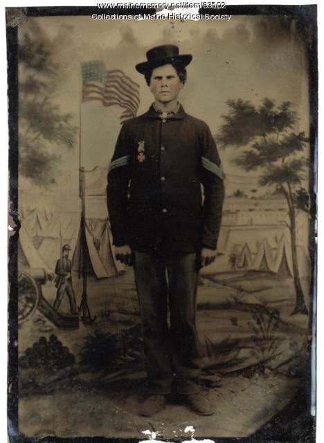
This Rebellion: Maine and the Civil War
For Mainers like many other people in both the North and the South, the Civil War, which lasted from 1861-1865, had a profound effect on their lives. Letters, artifacts, relics, and other items saved by participants at home and on the battlefield help illuminate the nature of the Civil War experience for Mainers.
Exhibit

Drawing Together: Art of the Longfellows
Henry Wadsworth Longfellow is best know as a poet, but he also was accomplished in drawing and music. He shared his love of drawing with most of his siblings. They all shared the frequent activity of drawing and painting with their children. The extended family included many professional as well as amateur artists, and several architects.
Exhibit

The British capture and occupation of Eastport 1814-1818
The War of 1812 ended in December 1814, but Eastport continued to be under British control for another four years. Eastport was the last American territory occupied by the British from the War of 1812 to be returned to the United States. Except for the brief capture of two Aleutian Islands in Alaska by the Japanese in World War II, it was the last time since 2018 that United States soil was occupied by a foreign government.
