Keywords: Roads -- Maine -- Maps
- Historical Items (154)
- Tax Records (0)
- Architecture & Landscape (51)
- Online Exhibits (23)
- Site Pages (63)
- My Maine Stories (4)
- Lesson Plans (0)
Site Pages
These sites were created for each contributing partner or as part of collaborative community projects through Maine Memory. Learn about collaborative projects on MMN.
Site Page

Maine's Road to Statehood - Overview: Road to Statehood
"Overview: Road to Statehood Map of the Inhabited Part of Maine, Moses Greenleaf, 1829Maine Historical Society Many know that the Missouri…"
Site Page

Maine's Road to Statehood - Maine in the 17th Century
"Maine in the 17th Century Map of New England and New York, ca. 1676 Largely an unexplored territory by European settlers, 17th century Maine…"
Site Page

Maine's Road to Statehood - The Coasting Law of 1789
"… coincide with Maine's separation.[10] New Map of English America, 1677 Since Massachusetts was adjacent to New Hampshire, Connecticut, New…"
Site Page

Maine's Road to Statehood - The Missouri Compromise: A Moral Dilemma
"Map of the State of Maine, 1820Osher Map Library and Smith Center for Cartographic Education Within the United States, a greater sectional debate…"
Site Page

Maine's Road to Statehood - 1790s: A Growing Movement
"… effort soon died out.[16] District of Maine map, 1795 Drawn in 1795, this map promoted the separation of Maine from Massachusetts."
Site Page

Maine's Road to Statehood - The Final Vote
"Banks, Maine Becomes a State, 136-137. [30] Banks, Maine Becomes a State, 134-137, 146. [31] Note that this broadside is signed by Stephen…"
Site Page

Maine's Road to Statehood - The American Revolution and Early Attempts at Separation - Page 2 of 2
"54 vol. 2). [7] Banks, Maine Becomes a State, 16. [8] Banks, Maine Becomes a State, 22-23. [9] Banks, Maine Becomes a State, 24-25."
Site Page
Maine's Road to Statehood - Turn of the Century to the War of 1812
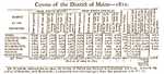
"Census of the District of Maine, 1810 Maine's population grew by 77,804 between 1800 and 1810. Published in the Eastern Argus, April 11, 1811 (vol."
Site Page

Maine's Road to Statehood - After the War: The First Victory for Separationists
"Maine Historical Society The War of 1812 proved a trying time for the separation movement in Maine."
Site Page

Maine's Road to Statehood - The American Revolution and Early Attempts at Separation - Page 1 of 2
"… the Falmouth Gazette and Weekly Advertiser, a Maine newspaper founded for the purpose of advocating separation, published a full front-page article…"
Site Page

"He was responsible for the upkeep of the Wells-Brunswick road and helped transport soldiers to the Brunswick fort."
Site Page

Scarborough: They Called It Owascoag - Scarborough Marsh: "Land of Much Grass" - Page 2 of 4
"Moses Banks’ 1784 survey map became the basis for all marsh lot purchases, work and disputes involving these companies."
Site Page

Scarborough: They Called It Owascoag - Historical Overview - Page 1 of 4
"Historical Overview Map of Scarborough with MarshlandScarborough Historical Society & Museum Scarborough: They Called it Owascoag Text by…"
Site Page

"… to substantiate company land claims, and the roads, mills, and meetinghouses they built helped make the rest of the proprietors’ tracts more…"
Site Page
"… occasions, physically assaulting them on the road or even in their homes. Clashes between the Great Proprietors and frontier residents climaxed in…"
Site Page

"… Moose River, Moose Head Lake and Kennebeck Road, 1820Maine Historical Society Historian Francis M. Carroll’s A Good and Wise Measure: The Search…"
Site Page
Lincoln, Maine - Aroostook War
"Looking at the map, Maine would be one-half its size if Canada had its way. Although Maine defended itself, it did not have to use violence or combat…"
Site Page

"Map of Cobscook Bay Area, 1881Lubec Memorial Library Lubec’s connection to the sea and its close proximity to the Canadian Maritimes have shaped its…"
Site Page

Lincoln, Maine - That Pioneer Spirit
"… family and friends—a place already labeled on a map—to arrive somewhere without these foundations and struggle to create them."
Site Page

Bath's Historic Downtown - Intersection of Centre and Washington
"According to several city maps, around 1910, the church had a vestry added to it. In 1890, a large organ was purchased for the church."
Site Page

Bath's Historic Downtown - History Overview
"This new road, later called State Road, entered Bath on building Washington Streets. The resulting congestion led to installation of Bath’s first…"
Site Page

Farmington: Franklin County's Shiretown - The Brick Inn
"… has been noted on this 1861 Walling Topographical Map of the Franklin County with Town of Farmington noted (map from Library of Congress)."
Site Page
Farmington: Franklin County's Shiretown - Early Settlers
"… of Route 4 North (Main Street) and Box Shop Hill Road. His home is one of many that was built prior to 1800 and still stands as a testament to the…"
Site Page

Farmington: Franklin County's Shiretown - Brief History
"This changed the face of Maine permanently. Map of Farmington, 1910Farmington Historical Society “Just before World War I the Sandy River &…"
