Keywords: Androscoggin River
- Historical Items (264)
- Tax Records (0)
- Architecture & Landscape (4)
- Online Exhibits (21)
- Site Pages (99)
- My Maine Stories (2)
- Lesson Plans (0)
Site Pages
These sites were created for each contributing partner or as part of collaborative community projects through Maine Memory. Learn about collaborative projects on MMN.
Site Page
Western Maine Foothills Region - Mt. Zircon Reservoir - Page 3 of 3
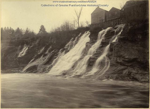
"Mt. Zircon Reservoir According to the Report to the Board of Trustees, dated March 27, 1915 by Head Engineer, E."
Site Page
Western Maine Foothills Region - Mt. Zircon Reservoir - Page 1 of 3
"Mt. Zircon Reservoir Text By Jane Welch Peterson, Nghia Ha & Dave Gawtry Images provided by: The Leo Blouin Family and donated to Rumford Area…"
Site Page
Western Maine Foothills Region - For The Love Of Paper - Page 3 of 4
"For The Love Of Paper THIRD GENERATION CHISHOLM LEADER William H. Chisholm was the third generation of his family to become President of Oxford."
Site Page

Western Maine Foothills Region - For The Love Of Paper - Page 4 of 4
"For The Love Of Paper Boise Cascade Corporation, a major player in the paper industry, was able to complete the purchase of the Oxford properties…"
Site Page

Western Maine Foothills Region - Dixfield's Church on the Hill
"Dixfield's Church on the Hill Dixfield Congregational Church, High Street, Dixfield, 2006.Dixfield Historical Society Text by Donna Towle…"
Site Page

"… Proprietors? Plan of the Kennebec River describing the Plymouth patent, ca. 1719Maine Historical Society The Kennebec Proprietors traced…"
Site Page

"… efforts to have land grants east of the Penobscot River confirmed by the Crown, as the charter required, were stymied."
Site Page

"Croix River (as well as its source), and deciding how to follow the long St. John (Wolostoq) River and its tributaries, which was made especially…"
Site Page

"… and Local Reality, 1763-1842 Moose River, Moose Head Lake and Kennebeck Road, 1820Maine Historical Society Historian Francis M."
Site Page

"… reflection of the cross-shaped conjunction of the rivers around it or as a reflection on the party’s hopes of using the site as a base for…"
Site Page

"The fundamental issue was that, in the years since Champlain’s voyage, the precise location of the river had been lost."
Site Page

"For example, in a 1659 Kennebec River deed, Nanudemance retained “liberty unto me and my heirs to fish, fowl, and hunt also to set otter traps…"
Site Page

"… from the northwesternmost head of the Connecticut River, through the Great Lakes, and the eastern border’s terminus at Lake of the Woods (the…"
Site Page

"… of land made in the area east of the Kennebec River would be legally recognized unless separately and specifically approved by the British crown."
Site Page

"… veteran, and his attempts at protecting the Sandy River; and Polin, in his attempts at protecting the Presumpscot River, both through diplomacy and…"
Site Page

"… named Paul Chadwick in 1809 along the Kennebec River sapped popular support for continued resistance, convincing most residents to finally settle…"
Site Page
"“A “Labyrinth of Uncertainties”: Penobscot River Islands, Land Assignments, and Indigenous Women Proprietors in Nineteenth-Century Maine.” The…"
Site Page

"… three million acres on both sides of the Kennebec River. In their squabbles with rival companies, they rejected what was by then a longstanding…"
Site Page
"… a passage through the rapids in the Adroscoggin river. Company (Check that HENRY) He remained active in overseeing his property until he was past…"
Site Page

"… a number of Irish families near the Kennebec River, the British briefly flirted with the idea of transforming the Sagadahock into its own colony…"
Site Page

"… square mile region on either side of the Kennebec River. The content of this collection pre‐ and post‐dates the period of the company’s operation…"
Site Page
Beyond Borders - Mapping Maine and the Northeast Boundary - Kennebec Proprietors Biographies
"… by reviving an old Pilgrim grant on the Kennebec River in Maine. This group of wealthy, well connected merchants organized as “The Proprietors of…"
Site Page

Strong, a Mussul Unsquit village - Strong's History - Page 1 of 4
"… the boundaries of certain lands lying around the Androscoggin River listed in the Pejepscot Claim. This tribe was friendlier with the English, so…"
Site Page

Maine's Paper & Heritage Museum
View collections, facts, and contact information for this Contributing Partner.
