Keywords: East Road
- Historical Items (175)
- Tax Records (6)
- Architecture & Landscape (0)
- Online Exhibits (44)
- Site Pages (79)
- My Maine Stories (4)
- Lesson Plans (0)
Site Pages
These sites were created for each contributing partner or as part of collaborative community projects through Maine Memory. Learn about collaborative projects on MMN.
Site Page

Swan's Island: Six miles east of ordinary - V. Changing times: the Swan’s Island Ferry
"… the island, requiring the construction of better roads and making travel between the separate island villages easier."
Site Page

"… in the mid to late 1800s—with new homes, better roads, and increased travel—made Swan’s Island a profitable enough location to gain a steamboat…"
Site Page

Bath's Historic Downtown - Old Town Hall and Grant Building
"… destroyed all of that block of Centre Street east to Front Street. Former Town/City Hall, Bath, ca."
Site Page

Bath's Historic Downtown - Bath Savings Institution and Hyde Block
"In 1975, a brick extension was added to the east side. The current building is made of brick on a granite foundation and is notable for its granite…"
Site Page

Surry by the Bay - Phebe Fowler: A Woman of Property
"… born November 17, 1841 and grew up on Morgan Bay Road in Surry, Maine. She was the only daughter of Benjamin and Jemima Lord and the youngest of…"
Site Page

Surry by the Bay - Early Twentieth Century
"If it rained, the clay roads were as slippery as snowy roads. With good conditions, they could take the ferry across the Penobscot River from…"
Site Page

Surry by the Bay - About The Project
"… (and later moved to its present site on the Surry Road) houses its collections, including a detailed, handwritten twentieth century census…"
Site Page

Surry by the Bay - Broadway by the Bay
"Program cover ca. 1930 All roads lead to the Surry PlayhouseSurry Historical Society Despite the Great Depression, the Surry Theater Company…"
Site Page

Surry by the Bay - Surry Village School
"This was partly due to town road improvements, which eliminated the need to close school for up to five weeks during “mud” season."
Site Page

Strong, a Mussul Unsquit village - Early Schools
"… School was situated on the old county road east of the Sandy River in the area now known as Norton Hill at Hunter Road."
Site Page

Western Maine Foothills Region - Dixfield - Page 3 of 5
"1914Dixfield Historical Society EAST DIXFIELD The Next Section to be Settled East Dixfield is a village within Dixfield that is divided by a common…"
Site Page

Cumberland & North Yarmouth - "Main Streets" of North Yarmouth and Cumberland
"New road construction projects were not always well received by property owners whose land was bisected by the new byways, and early records tell…"
Site Page

View collections, facts, and contact information for this Contributing Partner.
Site Page
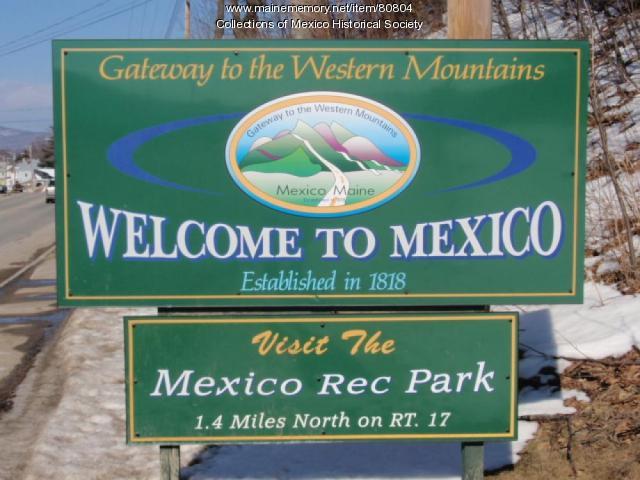
Western Maine Foothills Region - Mexico - Page 1 of 3
"A rambling vernacular Greek Revival farmstead was built on this road by Joel White. In the 1850s it was Morrill Farm."
Site Page

Mount Desert Island: Shaped by Nature - The Founding of Acadia National Park
"The roads, which were mostly within the park, were open to walkers, bicycles, skiers and, of course, carriages -- but no motor vehicles."
Site Page

Blue Hill, Maine - Blue Hill Spearheads Development on the Downeast Coast
"… a Place called Sandy Point and to run East North East Eight Miles, then South South East to the Ocean and then West South West Eight miles and then…"
Site Page

View collections, facts, and contact information for this Contributing Partner.
Site Page

View collections, facts, and contact information for this Contributing Partner.
Site Page

"Half of their business was in the Far East: particularly China, India, and Southeast Asia. Tremendous numbers of workers were needed for the textile…"
Site Page
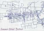
Highlighting Historical Hampden - Summer Street
"… past than that of Summer Street, bordered on the east by the Penobscot River and on the west by the Main Road (Rout 1A)."
Site Page

Swan's Island Historical Society
View collections, facts, and contact information for this Contributing Partner.
Site Page
Western Maine Foothills Region - Regional and Town History
"… miles, RSU 10 is the largest school district east of the Mississippi; within it’s capacious boundaries lie a number of interesting features…"
Site Page

View collections, facts, and contact information for this Contributing Partner.
Site Page

View collections, facts, and contact information for this Contributing Partner.
