Keywords: Kennebec River (Me.)Kennebec River (Me.)
- Historical Items (709)
- Tax Records (0)
- Architecture & Landscape (1)
- Online Exhibits (28)
- Site Pages (249)
- My Maine Stories (2)
- Lesson Plans (0)
Site Pages
These sites were created for each contributing partner or as part of collaborative community projects through Maine Memory. Learn about collaborative projects on MMN.
Site Page
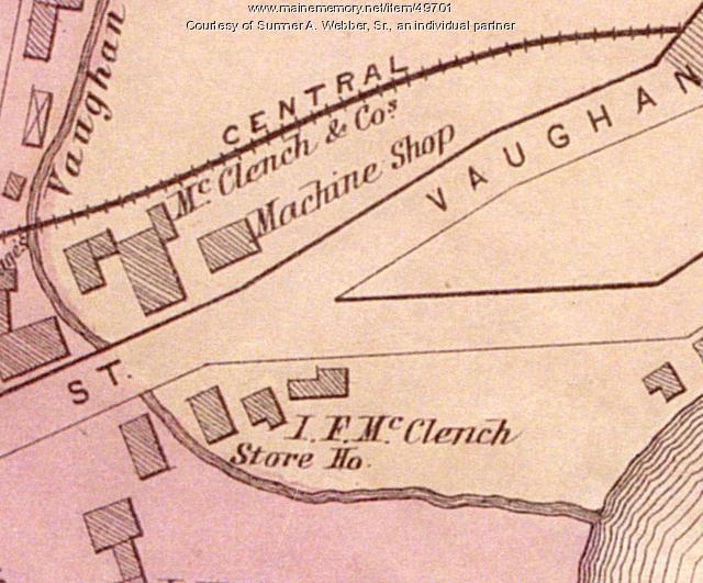
Historic Hallowell - Industry at the Mouth of the Vaughan Stream
"Industry at the Mouth of the Vaughan Stream Jake Allen, Ethan Ballew & Avery Page McClench Machine Shop, Hallowell, 1879Courtesy of Sumner A."
Site Page
Historic Hallowell - Hallowell Ice Storm Poem
"Hallowell Ice Storm Poem Hallowell Ice Storm Poem By Clio Barr Innocent, raw raindrops were the prelude, landing sneakily on branch and pavement."
Site Page
Life on a Tidal River - Four Important Women of Bangor
"… War II Nurse from Maine Subject of New Book.” Kennebec Journal and Morning Sentinel, Kennebec Journal and Morning Sentinel, 20 June 2015…"
Site Page
"Who were the Kennebec and Pejepscot Proprietors? Coll. 61, vol. 7, pg. 401 Example of a proprietor meeting at the Royall Exchange Tavern on King…"
Site Page
"Who were the Kennebec and Pejepscot Proprietors? Essay by Ian Saxine, Fall 2022 Ian Saxine, PhD, is an Assistant Professor of History at…"
Site Page
"Who were the Kennebec and Pejepscot Proprietors? Coll. 61, vol. 10, p. 179b-1 A copy of a letter issued by Samuel Goodwin to Mr."
Site Page
"Who were the Kennebec and Pejepscot Proprietors? Brunswick Town Meeting Minutes, 1719Maine Historical Society The Pejepscot Proprietors…"
Site Page
Maine Bureau of Parks and Lands
View collections, facts, and contact information for this Contributing Partner.
Site Page
Beyond Borders - Mapping Maine and the Northeast Boundary - People
"Map by Francis Joseph Neptune, Cobscook River, 1798 Map by cartographer Chief Francis Joseph Neptune (Passamaquoddy), 1798Maine Historical Society…"
Site Page
"… parcels for major settlements, and the Kennebec River watershed where the Kennebec Proprietors claimed and sold large tracts of land, including…"
Site Page
"For example, in a 1659 Kennebec River deed, Nanudemance retained “liberty unto me and my heirs to fish, fowl, and hunt also to set otter traps…"
Site Page
"The Kennebec Proprietors maps document the continuance of Wabanaki people at Norridgewock, despite a persistent myth that Norridgewock was…"
Site Page
"… appeared along with “Great Agumagus” or Moxus, a Kennebec River leader, and Sheepscot John, a Wabanaki leader on the coast."
Site Page
"… no grants of land made in the area east of the Kennebec River would be legally recognized unless separately and specifically approved by the…"
Site Page
"… of some three million acres on both sides of the Kennebec River. In their squabbles with rival companies, they rejected what was by then a…"
Site Page
"… to settle a number of Irish families near the Kennebec River, the British briefly flirted with the idea of transforming the Sagadahock into its own…"
Site Page
"… settlement was established at the mouth of the Kennebec River. Known as the Popham or Sagadahock Colony, it barely lasted a year, from 1607-1608."
Site Page
"… based on Native titles, their main rival, the Kennebec Proprietors claim was founded on an ancient grant of Land from the King to the Plymouth…"
Site Page
"… husband, Ephraim, was surveyor and agent for the Kennebec Proprietors, and so generated extensive documentation within its papers."
Site Page
"Notably, the Kennebec Proprietors pled with him to be reimbursed for the Crown appropriating large amounts of timber for the Royal Navy, which he…"
Site Page
"Croix River. In the Passamaquoddy language the river was known as the Skutik River. Several testimonies were given about the location of the true St."
Site Page
Bath's Historic Downtown - The Railroad Station
"… ferries began carrying train cars across the Kennebec River to the Knox and Lincoln railroad line that ran from Woolwich to Rockland."
Site Page
Western Maine Foothills Region - Dixfield - Page 1 of 5
"Years later their efforts turned into the Coos Road, running from northern Vermont down the Androscoggin and Sandy River valleys to Hallowell."
Site Page
"… efforts to have land grants east of the Penobscot River confirmed by the Crown, as the charter required, were stymied."


