Keywords: Maps, Early
- Historical Items (266)
- Tax Records (0)
- Architecture & Landscape (0)
- Online Exhibits (29)
- Site Pages (166)
- My Maine Stories (7)
- Lesson Plans (0)
Site Pages
These sites were created for each contributing partner or as part of collaborative community projects through Maine Memory. Learn about collaborative projects on MMN.
Site Page

Hamlin Memorial Library and Museum
View collections, facts, and contact information for this Contributing Partner.
Site Page

Scarborough: They Called It Owascoag - Scarborough Marsh: "Land of Much Grass" - Page 2 of 4
"Moses Banks’ 1784 survey map became the basis for all marsh lot purchases, work and disputes involving these companies."
Site Page

Cumberland & North Yarmouth - Our Shared History - Page 2 of 4
"Cumberland Map X Cumberland’s Secession: 1821 This church split foreshadowed the secession of the town of Cumberland from North Yarmouth, which…"
Site Page

View collections, facts, and contact information for this Contributing Partner.
Site Page

Islesboro--An Island in Penobscot Bay - Water Transportation
"The Smith herself cost $3 million. This ferry, still in service, can carry 250 passengers and 33 cars. map of Islesboro "
Site Page

Frye Island Historical Society
View collections, facts, and contact information for this Contributing Partner.
Site Page

Islesboro--An Island in Penobscot Bay - Businesses and Cottage Industries
"Businesses and Cottage Industries map of Islesboro Text by John Mitchell Blacksmith, Islesboro, ca."
Site Page

Islesboro--An Island in Penobscot Bay - Schools
"Schools map of Islesboro Text by Ruth Hartley School Bell, Islesboro, ca. 1880Islesboro Historical Society After incorporating as a town in…"
Site Page

Scarborough: They Called It Owascoag - Historical Overview - Page 1 of 4
"Historical Overview Map of Scarborough with MarshlandScarborough Historical Society & Museum Scarborough: They Called it Owascoag Text by…"
Site Page

Westport Island History Committee
View collections, facts, and contact information for this Contributing Partner.
Site Page

Cumberland & North Yarmouth - "Main Streets" of North Yarmouth and Cumberland
"This has made Greely Road look like a zipper on a map! Cumberland Center Points of Interest The Buxton house at 363 Main Street, at the corner of…"
Site Page

Western Maine Foothills Region - Regional and Town History
"Google Maps tells us that the distance between Byron and Buckfield—respectively the northern and southern-most towns in RSU 10—is 43 miles, with a…"
Site Page

Scarborough Historical Society & Museum
View collections, facts, and contact information for this Contributing Partner.
Site Page

"Map of Cobscook Bay Area, 1881Lubec Memorial Library Lubec’s connection to the sea and its close proximity to the Canadian Maritimes have shaped its…"
Site Page
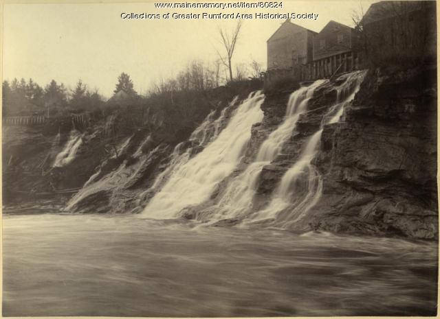
Western Maine Foothills Region - Rumford High School Basketball - 1970s - Page 1 of 2
"… of the 1970’s that really put the town “on the map” with its sports prominence. In a recent Bangor Daily News farewell to the Auditorium article…"
Site Page

Life on a Tidal River - Four Important Women of Bangor
"“Cemetery Map - Mount Hope Cemetery Corp & Crematory - America's Second Garden Cemetery.” Mount Hope Cemetery Corp & Crematory, Mount Hope Cemetery…"
Site Page

View collections, facts, and contact information for this Contributing Partner.
Site Page

Islesboro--An Island in Penobscot Bay - Historical Overview
"Historical Overview map of Islesboro by Olivia Boucher and Melissa L. Olson Survey Chart, Islesboro, 1884Islesboro Historical Society…"
Site Page

Blue Hill, Maine - Educating Blue Hill
"In early Jonathan Fisher maps of the late 1700's, scattered schoolhouses can be seen around the town."
Site Page

Presque Isle: The Star City - History of Presque Isle
"History of Presque Isle Map of Presque Isle, ca. 1870Presque Isle Historical Society Text by: Kimberly R."
Site Page
Lincoln, Maine - That Pioneer Spirit
"… family and friends—a place already labeled on a map—to arrive somewhere without these foundations and struggle to create them."
Site Page

Life on a Tidal River - Four Famous Bangorians
"… very important in putting Maine on the national map. He was known as one of the best congressmen the state ever had."
