Keywords: Roads -- Maine -- Maps
- Historical Items (154)
- Tax Records (0)
- Architecture & Landscape (51)
- Online Exhibits (23)
- Site Pages (63)
- My Maine Stories (4)
- Lesson Plans (0)
Site Pages
These sites were created for each contributing partner or as part of collaborative community projects through Maine Memory. Learn about collaborative projects on MMN.
Site Page

Cumberland & North Yarmouth - "Main Streets" of North Yarmouth and Cumberland
"New road construction projects were not always well received by property owners whose land was bisected by the new byways, and early records tell…"
Site Page

Farmington: Franklin County's Shiretown - Agriculture
"Regional History Reprints. Originally published in 1846. Franklin Chronicle Newspapers. 1840-1918. Various magazine articles and maps."
Site Page

Blue Hill, Maine - Educating Blue Hill
"In early Jonathan Fisher maps of the late 1700's, scattered schoolhouses can be seen around the town."
Site Page
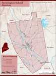
Farmington: Franklin County's Shiretown - Education
"Education Click the icon to see a map of the early schools of Farmington. X By Nancy Porter, Researcher and Page Creator With images from…"
Site Page

Western Maine Foothills Region - Regional and Town History
"Google Maps tells us that the distance between Byron and Buckfield—respectively the northern and southern-most towns in RSU 10—is 43 miles, with a…"
Site Page

Lubec, Maine - Canning Sardines in Lubec: Technology, the Syndicate and Labor
"… of on-ground realities, the Sanborn Insurance maps, offer testimony. Canneries in Lubec in the 1903 edition show rooms labeled as places where cans…"
Site Page

Bath's Historic Downtown - Project Resources
"Hammett, circa 1830. City of Bath, Lincoln County, Maine. A. G. Gillet, Publisher, 1851. Sagadahoc County, Maine. J. Chace, Publisher, 1858."
Site Page

Bath's Historic Downtown - The Customs House
"1901Patten Free Library According to the 1851 map of Bath, three separate buildings occupied the property where the Customs House was later built."
Site Page

Bath's Historic Downtown - Project Overview
"Students attempted to fill in blank maps of the city, list as many facts as they could recall, and pose thoughtful questions on topics that they were…"
Site Page

Farmington: Franklin County's Shiretown - Measuring Rock
"Blunt’s Brook crosses the road just north of the Measuring Rock. References: • The History of Brunswick, Topsham, and Harpswell, Maine, 1878, by…"
Site Page
Bath's Historic Downtown - 94 Front Street
"… in the early 1850s, according to the 1858 map of Bath, and city tax records, David Tilden Stinson rented the location from Oliver Moses, running a…"
Site Page

Farmington: Franklin County's Shiretown - Lowell's General Store, Commerce, & the Railroad
"… Society The Lowell homestead was on the Whittier Road, (now # 655 Whittier Road). “The orchards had 1,000 or more trees and each fall Lowell…"
Site Page
Farmington: Franklin County's Shiretown - Railroad into the Village
"… of acting upon the question of accepting a road, or roads, laid out to the new depot grounds by the selectmen."
Site Page
Farmington: Franklin County's Shiretown - Meeting House Park
"That small brick structure set back away from the road. The flames however crossed Main Street and took the Baptist Church, stayed on the west side…"
Site Page
Farmington: Franklin County's Shiretown - Chester Greenwood
"… in a committee to research and build better roads for the town. He was active in the Unitarian Church with his wife, Isabel."
Site Page

Winter Harbor Historical Society
View collections, facts, and contact information for this Contributing Partner.
Site Page

View collections, facts, and contact information for this Contributing Partner.
Site Page

John Martin: Expert Observer - Plan of North End of Bangor, 1844
"Since this map has a specific date, he may have recopied into the journal from earlier notes. He provided details about each building and feature…"
Site Page

Thomaston: The Town that Went to Sea - Prison is Established - 1823
"Location of Maine State Prison from Early Map, Thomaston, Maine 1855Thomaston Historical Society In May of 1823, the Thomaston site was accepted as…"
Site Page

Islesboro--An Island in Penobscot Bay - Early Settlements
"… in 1864 to educate those who resided on the Main Road between North Islesboro and Pripet. Guinea, Islesboro, c."
Site Page

Thomaston: The Town that Went to Sea - Thomaston Narrative
"Map of the New England Coast, 1610Maine Historical Society In 1605, after making landfall at Monhegan, Captain Waymouth re-anchored his ship…"
Site Page

Westport Island History Committee
View collections, facts, and contact information for this Contributing Partner.
Site Page

Thomaston: The Town that Went to Sea - Early Shipbuilders - 1780s
"… Early Shipbuilders - 1780s Map of the Georges River, Thomaston, Maine 2009Thomaston Historical Society By the time Thomaston was…"
Site Page

Islesboro--An Island in Penobscot Bay - Summer Resorts
"… shore, the Hewes Point landing was near the Main Road and the former community of Guinea. Hewes Point residents, summer and year-round, had easy…"
