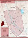
Keywords: lot map
- Historical Items (206)
- Tax Records (0)
- Architecture & Landscape (5)
- Online Exhibits (16)
- Site Pages (37)
- My Maine Stories (2)
- Lesson Plans (0)
Site Pages
These sites were created for each contributing partner or as part of collaborative community projects through Maine Memory. Learn about collaborative projects on MMN.
Site Page

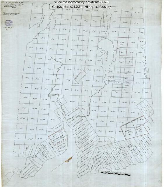
Beyond Borders - Mapping Maine and the Northeast Boundary - Pejepscot Proprietors Papers, 1627‐1866
"Pejepscot Proprietors Papers, 1627‐1866 Map of lots on Maquoit & Merriconeeg, ca. 1719Maine Historical Society Coll."
Site Page

"… pointing out that the proprietors hoarded choice lots for their own use, hindering community prosperity."
Site Page

"… Freeman to collect payments, sell additional lots, and to deal with squatters or colonists cutting down timber on unsold company lands."
Site Page

"Land—lots of it—was a means to that end. In 1714, for instance, eight Boston men established the Pejepscot Company, which claimed a large tract…"
Site Page

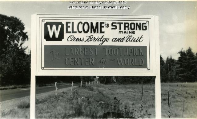
Strong, a Mussul Unsquit village - The Bridge That Changed The Map
"The map was changed X But the map had already been changed. In 1861 the legislature had approved the petition of the residents of East Strong."
Site Page

Farmington: Franklin County's Shiretown - The Brick Inn
"Over the years, the original lot was pared down, selling pieces off to people whose land abutted the original Belcher Lot."
Site Page

Farmington: Franklin County's Shiretown - Early Settlers
"Early Settlers Click the icon for a map of the locations of early settler's homesteads X By Nancy Porter, Researcher & Page Creator With…"
Site Page

Farmington: Franklin County's Shiretown - Brief History
"… Library, and Maine Historical Society 1794 map of FarmingtonFarmington Historical Society "Farmington is undoubtly one of the best…"
Site Page
Farmington: Franklin County's Shiretown - Education
"Education Click the icon to see a map of the early schools of Farmington. X By Nancy Porter, Researcher and Page Creator With images from…"
Site Page

Farmington: Franklin County's Shiretown - Titcomb Ski Slope, Farmington, ca. 1960
"… lodge, skiers on the slope, and the parking lot. Note that this ski slope is on Morrison Hill and not on Titcomb Hill."
Site Page
Farmington: Franklin County's Shiretown - Measuring Rock
"Each lot was 100 rods long and extended 1 mile from the river. Stephen Titcomb’s lot was the most northern of the six."
Site Page

"Each lot was 100 rods long and extended 1 mile from the river. Stephen Titcomb’ s lot was the most northern of the six."
Site Page
Farmington: Franklin County's Shiretown - Chester Greenwood
"All of his children attended college. There truly was a lot more to Chester than just being the inventor of ear protectors."
Site Page

Farmington: Franklin County's Shiretown - Lowell's General Store, Commerce, & the Railroad
"… “Due to the amount of livestock, it takes a lot of grain to feed working teams of horses and oxen.” (Teams were not only on farms but were working…"
Site Page

Farmington: Franklin County's Shiretown - North Church
"They purchased the lot on the northeast corner of High Street and Court Street and built the North Church in 1973."
Site Page

Scarborough: They Called It Owascoag - Scarborough Marsh: "Land of Much Grass" - Page 2 of 4
"Many settlers were often assigned a marsh lot (or lots) for grazing their animals, later deeding these lots to their heirs."
Site Page

Cumberland & North Yarmouth - Our Shared History - Page 1 of 4
"In 1727, the plantation was divided and mapped indicating specific land lots and ownership. North Yarmouth’s boundary with Falmouth was reestablished…"
Site Page

Thomaston: The Town that Went to Sea - Prison is Established - 1823
"Location of Maine State Prison from Early Map, Thomaston, Maine 1855Thomaston Historical Society In May of 1823, the Thomaston site was accepted as…"
Site Page

Mount Desert Island: Shaped by Nature - Early Settlement
"Despite purchasing the lot sometime around 1820, the deeds and clear title for Lot 67 to Roberts and Savage were obtained later on in 1846 from…"
Site Page
Strong, a Mussul Unsquit village - Student Research
"The 8th graders also worked on a digital map. The project topics chosen were: Our Conclusions As we looked at the lists of the hundreds of men who…"
Site Page

Cumberland & North Yarmouth - Our Shared History - Page 2 of 4
"Cumberland Map X Cumberland’s Secession: 1821 This church split foreshadowed the secession of the town of Cumberland from North Yarmouth, which…"
Site Page
Surry by the Bay - Early Settlement
"1880Maine Historical Society Border Dispute Originally, Surry extended to the Union River and north to Ellsworth Falls. On an early settler map of…"
Site Page

Mount Desert Island: Shaped by Nature - The Savage Family of Mount Desert
"… of original correspondence, photographs, maps, written and oral histories, business records, and ephemera to develop our exhibits."
Site Page

"Northeast Harbor Village Map, ca. 1955Northeast Harbor Library The Future That Northeast Harbor is in economic decline, there is no doubt."
