Search Results

Keywords: Maine--History--Colonial period, ca. 1600-1775

Historical Items

View All Showing 2 of 446 Showing 3 of 446

Item 5335

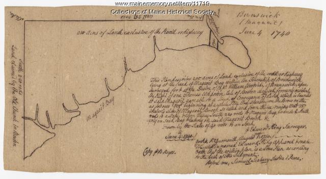
Brunswick and Topsham, ca. 1730

Contributed by: Maine Historical Society Date: circa 1730 Location: Brunswick; Topsham Media: Ink on paper

Item 135882

Manuscript map of Maine, 1761

Contributed by: Osher Map Library and Smith Center for Cartographic Education Date: 1761 Media: Ink on paper

Item 11719

"Maquoit," Brunswick, 1740

Contributed by: Maine Historical Society Date: 1740-06-04 Location: Brunswick Media: Ink on paper

Online Exhibits

View All Showing 2 of 3 Showing 3 of 3

Exhibit

Indians, Furs, and Economics

When Europeans arrived in North America and disrupted traditional Native American patterns of life, they also offered other opportunities: trade goods for furs. The fur trade had mixed results for the Wabanaki.

Exhibit

Settling along the Androscoggin and Kennebec

The Proprietors of the Township of Brunswick was a land company formed in 1714 and it set out to settle lands along the Androscoggin and Kennebec Rivers in Maine.

Exhibit

Father Rasles, the Indians and the English

Father Sebastien Rasle, a French Jesuit, ran a mission for Indians at Norridgewock and, many English settlers believed, encouraged Indian resistance to English settlement. He was killed in a raid on the mission in 1724 that resulted in the remaining Indians fleeing for Canada.

Site Pages

View All Showing 2 of 49 Showing 3 of 49

Site Page

Beyond Borders - Mapping Maine and the Northeast Boundary - The Plymouth Company (Kennebec Proprietors) records, ca. 1625-1824

"… of this collection pre‐ and post‐dates the period of the company’s operation (1749‐1816). The collection includes bound or once bound volumes of…"

Site Page

Beyond Borders - Mapping Maine and the Northeast Boundary - Fixing Borders on the Land: The Northeastern Boundary in Treaties and Local Reality, 1763-1842 - Page 1 of 5

"… Canada was created by human actions over a long period of time and was not formed by a natural or organic process."

Site Page

Beyond Borders - Mapping Maine and the Northeast Boundary - Fixing Borders on the Land: The Northeastern Boundary in Treaties and Local Reality, 1763-1842 - Page 3 of 5

"The geographic range of maps produced in this period, to the east in 1817 and to the west in 1820 arose from the opaque issues at stake as well as…"