Keywords: Back River
- Historical Items (137)
- Tax Records (0)
- Architecture & Landscape (0)
- Online Exhibits (74)
- Site Pages (166)
- My Maine Stories (17)
- Lesson Plans (0)
Online Exhibits
Your results include these online exhibits. You also can view all of the site's exhibits, view a timeline of selected events in Maine History, and learn how to create your own exhibit. See featured exhibits or create your own exhibit
Exhibit

Student Exhibit: Logging on Kennebec River
I became interested in the Kennebec River log drive when my grandfather would tell me stories. He remembers watching the logs flow down the river from his home in Fairfield, a small town along the Kennebec River.
Exhibit

Walter Wyman's vision to capture the power of Maine's rivers to produce electricity led to the formation of Central Maine Power Co. and to a struggle within the state over what should happen to the power produced by the state's natural resources.
Exhibit

Melting snow, ice, warmer temperatures, and rain sometimes bring floods to Maine's many rivers and streams. Floods are most frequent in the spring, but can occur at any season.
Exhibit

In 1893, F.C. Whitehouse of Topsham, who owned paper mills in Topsham and Lisbon Falls, began construction of a third mill on the eastern banks of the Androscoggin River five miles north of Topsham. First, he had to build a dam to harness the river's power.
Exhibit
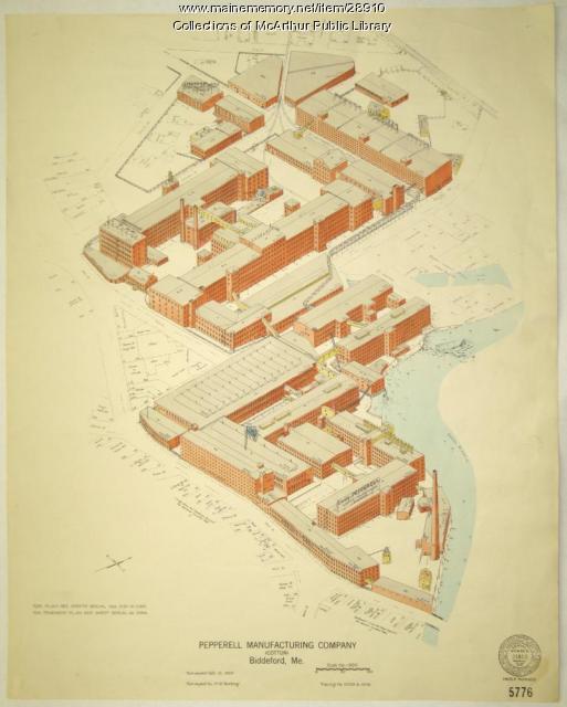
Biddeford, Saco and the Textile Industry
The largest textile factory in the country reached seven stories up on the banks of the Saco River in 1825, ushering in more than a century of making cloth in Biddeford and Saco. Along with the industry came larger populations and commercial, retail, social, and cultural growth.
Exhibit

The Swinging Bridge: Walking Across the Androscoggin
Built in 1892 to entice workers at the Cabot Manufacturing Corporation in Brunswick to move to newly built housing in Topsham, the Androscoggin Pedestrian "Swinging" Bridge or Le Petit Pont quickly became important to many people traveling between the two communities.
Exhibit

Colonial Cartography: The Plymouth Company Maps
The Plymouth Company (1749-1816) managed one of the very early land grants in Maine along the Kennebec River. The maps from the Plymouth Company's collection of records constitute some of the earliest cartographic works of colonial America.
Exhibit

Wired! How Electricity Came to Maine
As early as 1633, entrepreneurs along the Piscataqua River in southern Maine utilized the force of the river to power a sawmill, recognizing the potential of the area's natural power sources, but it was not until the 1890s that technology made widespread electricity a reality -- and even then, consumers had to be urged to use it.
Exhibit

Visitors to the Maine woods in the early twentieth century often recorded their adventures in private diaries or journals and in photographs. Their remembrances of canoeing, camping, hunting and fishing helped equate Maine with wilderness.
Exhibit

Princeton: Woods and Water Built This Town
Princeton benefited from its location on a river -- the St. Croix -- that was useful for transportation of people and lumber and for powering mills as well as on its proximity to forests.
Exhibit

Student Exhibit: Benedict Arnold's March Through Skowhegan
Benedict Arnold arrived in Skowhegan on October 4th, 1775, and it was here that Arnold received his first offer of help from the colonists. Joseph Weston and his sons helped Benedict Arnold and his army cross over the Skowhegan Falls, but Joseph later got a severe cold from exposure and died of a fever on Oct.16th. His sons went back to the family home along the Kennebec for they were the first family to settle in Old Canaan or what is now Skowhegan.
Exhibit

The paper mill on the Penobscot River in South Brewer, which became known as Eastern Fine Paper Co., began as a sawmill in 1884 and grew over the years as an important part of the economy of the region and a large presence in the landscape. Its closing in 2005 affected more than the men and women who lost their jobs.
Exhibit

Begin Again: reckoning with intolerance in Maine
BEGIN AGAIN explores Maine's historic role, going back 528 years, in crisis that brought about the pandemic, social and economic inequities, and the Black Lives Matter movement in 2020.
Exhibit

Student Exhibit: Somerset Railroad
The Somerset Railroad was completed in 1872. It started out as a dream to link the Maine Coast with Canadian businesses to the north. It ran from the North Woods around Moosehead Lake down to Southern Maine and back again for 56 years.
Exhibit

John Hancock's Relation to Maine
The president of the Continental Congress and the Declaration's most notable signatory, John Hancock, has ties to Maine through politics, and commercial businesses, substantial property, vacations, and family.
Exhibit

Maine Eats: the food revolution starts here
From Maine's iconic lobsters, blueberries, potatoes, apples, and maple syrup, to local favorites like poutine, baked beans, red hot dogs, Italian sandwiches, and Whoopie Pies, Maine's identity and economy are inextricably linked to food. Sourcing food, preparing food, and eating food are all part of the heartbeat of Maine's culture and economy. Now, a food revolution is taking us back to our roots in Maine: to the traditional sources, preparation, and pleasures of eating food that have sustained Mainers for millennia.
Exhibit

These stories -- that stretch from 1999 back to 1759 -- take you from an amusement park to the halls of Congress. There are inventors, artists, showmen, a railway agent, a man whose civic endeavors helped shape Portland, a man devoted to the pursuit of peace and one known for his military exploits, Maine's first novelist, a woman who recorded everyday life in detail, and an Indian who survived a British attack.
Exhibit

Student Exhibit: A Friend in Need!
Sometime in the 1920s a 700 hundred pound moose fell through the ice, likely between Norridgewock and Skowhegan. She was rescued by a game warden and another man. Here is the story.
Exhibit

After the canoe, steamboats became the favored method of transportation on Moosehead Lake. They revolutionized movement of logs and helped promote tourism in the region.
Exhibit

The boundaries of Maine are the product of international conflict, economic competition, political fights, and contested development. The boundaries are expressions of human values; people determined the shape of Maine.
Exhibit

Student Exhibit: The Great By-Pass
The debate over a proposed bridge and bypass in Skowhegan in 2005.
Exhibit

Washington County Through Eastern's Eye
Images taken by itinerant photographers for Eastern Illustrating and Publishing Company, a real photo postcard company, provide a unique look at industry, commerce, recreation, tourism, and the communities of Washington County in the early decades of the twentieth century.
Exhibit

A Convenient Soldier: The Black Guards of Maine
The Black Guards were African American Army soldiers, members of the segregated Second Battalion of the 366th Infantry sent to guard the railways of Maine during World War II, from 1941 to 1945. The purpose of the Black Guards' deployment to Maine was to prevent terrorist attacks along the railways, and to keep Maine citizens safe during the war.
Exhibit

Photojournalism & the 1936 Flood
Photojournalism & the 1936 Flood examines the monumental destruction caused by the historic flood of 1936 through the comprehensive and innovative photojournalism done by the Guy Gannett Publishing Company in the weeks surrounding the flood.
